South Carolina Highway 245 | ||||
|---|---|---|---|---|
 | ||||
| Route information | ||||
| Maintained by SCDOT | ||||
| Length | 5.060 mi[1] (8.143 km) | |||
| Existed | 1931–present | |||
| Major junctions | ||||
| South end | ||||
| North end | ||||
| Location | ||||
| Country | United States | |||
| State | South Carolina | |||
| Counties | Lexington | |||
| Highway system | ||||
| ||||
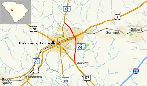
South Carolina Highway 245 (SC 245) is a 5.060-mile-long (8.143 km) state highway in the U.S. state of South Carolina. The highway was built and paved in 1932 as a short spur of SC 24 passing north through Leesville to connect with SC 391.[2] Since being built, that section of SC 24 was redesignated as US 178 in 1933, and Leesville merged in 1992 with Batesburg, where US 1 and SC 391 intersect, to form the town of Batesburg-Leesville. It is known locally as North Lee Street north of the railroad tracks, and as South Lee Street south of the railroad tracks. There are two traffic lights along SC 245.[3]
Major intersections
The entire route is in Lexington County.
| Location | mi[1] | km | Destinations | Notes | |
|---|---|---|---|---|---|
| | 0.000 | 0.000 | Southern terminus | ||
| Batesburg-Leesville | 2.980 | 4.796 | |||
| 3.100 | 4.989 | ||||
| | 5.060 | 8.143 | |||
| 1.000 mi = 1.609 km; 1.000 km = 0.621 mi | |||||
See also
References
- 1 2 "Highway Logmile Report". South Carolina Department of Transportation. Retrieved December 26, 2020.
- ↑ General Highway System - Lexington County, South Carolina (PDF) (Map). South Carolina Department of Transportation. August 2005. Retrieved February 2, 2013.
- ↑ Google (February 2, 2013). "South Carolina Highway 245" (Map). Google Maps. Google. Retrieved February 2, 2013.
External links
Template:Attached KML/South Carolina Highway 245
KML is from Wikidata
Wikimedia Commons has media related to South Carolina Highway 245.
This article is issued from Wikipedia. The text is licensed under Creative Commons - Attribution - Sharealike. Additional terms may apply for the media files.
