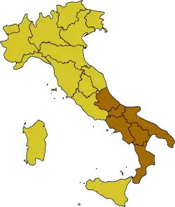
South Italy
| |
|---|---|
 | |
| Country | Italy |
| Regions | |
| Area | |
| • Total | 73,223 km2 (28,272 sq mi) |
| Population | |
| • Estimate (2022) | 13,430,686 |
| Languages | |
| – Official language | Italian |
| – Official linguistic minorities[2] | |
| – Regional languages | |
South Italy (Italian: Italia meridionale or Sud Italia) is one of the five official statistical regions of Italy used by the National Institute of Statistics (ISTAT), a first level NUTS region and a European Parliament constituency. South Italy encompasses six of the country's 20 regions:
South Italy is defined only for statistical and electoral purposes. It should not be confused with the Mezzogiorno, or Southern Italy, which refers to the areas of the former Kingdom of the Two Sicilies (once including the southern half of the Italian peninsula and Sicily) with the usual addition of the Western Mediterranean island of Sardinia. The latter and Sicily form a distinct statistical region, called Insular Italy.
Geography
South Italy borders central Italy to the northwest, while it is washed by the Adriatic Sea to the northeast, the Ionian Sea to the southeast and the Tyrrhenian Sea to the southwest.
The territory of south Italy is predominantly hilly and mountainous. The largest plains are the Tavoliere delle Puglie (second largest plain on the Italian peninsula), the Tavoliere salentino, the Campania plain, the Sele plain, the Metaponto plain, the Sibari plain and the Gioia Tauro plain. It is crossed from north to south by the Apennine Mountains, whose highest mountain is the Gran Sasso d'Italia (2,912 m or 9,554 ft).
Demography
In 2022, the population resident in south Italy amounts to 13,430,686 inhabitants.[1]
Regions
| Region | Capital | Inhabitants |
|---|---|---|
| L'Aquila | 1,269,860 | |
| Bari | 3,900,852 | |
| Potenza | 536,659 | |
| Catanzaro | 1,841,300 | |
| Naples | 5,592,175 | |
| Campobasso | 289,840 |
Most populous municipalities


Below is the list of the population residing in 2022 in municipalities with more than 50,000 inhabitants:[1]
Economy
The gross domestic product (GDP) of the region was 271.1 billion euros in 2018, accounting for 15.4% of Italy's economic output. The GDP per capita adjusted for purchasing power was 19,300 euros, or 64% of the EU27 average in the same year.[3]
See also
References
- 1 2 3 "Bilancio demografico e popolazione residente per sesso al 31 dicembre 2022" (in Italian). Retrieved 29 July 2023.
- ↑ "Legge 482". Webcitation.org. Archived from the original on 24 September 2015. Retrieved 2015-10-17.
- ↑ "Regional GDP per capita ranged from 30% to 263% of the EU average in 2018". Eurostat.
| History |
| ||||||||||||||||
|---|---|---|---|---|---|---|---|---|---|---|---|---|---|---|---|---|---|
| Geography | |||||||||||||||||
| Politics | |||||||||||||||||
| Economy | |||||||||||||||||
| Society |
| ||||||||||||||||
| |||||||||||||||||