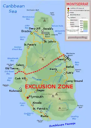
South Soufriere Hills is a 35 ha patch of forest on the island of Montserrat, a British Overseas Territory in the Leeward Islands of the Caribbean Sea. It forms one of the territory's Important Bird Areas (IBAs).[1]
Description

The IBA comprises the largest remnant of Montserrat's native forest in the Soufrière Hills, in the exclusion zone. It has survived the volcanic eruptions and pyroclastic flows that have devastated and depopulated the southern half of the island since the late 1990s. It lies only about 1.5 km south of 915 m Chances Peak, the highest point of the island and the Soufrière Hills stratovolcano. It ranges in elevation from 200 to 750 m above sea level and contains tropical evergreen forest. Other IBAs on the island are the Northern Forested Ghauts and Centre Hills.[1]
Birds
The IBA was identified as such by BirdLife International because it supports, populations of bridled quail-doves, green-throated caribs, Antillean crested hummingbirds, scaly-breasted thrashers, pearly-eyed thrashers, brown tremblers, forest thrushes, Montserrat orioles and Lesser Antillean bullfinches.[1]
References
- 1 2 3 "South Soufriere Hills". Important Bird Areas factsheet. BirdLife International. 2014. Retrieved 2014-04-17.
16°42′00″N 62°10′00″W / 16.70000°N 62.16667°W