St. Johns | |
|---|---|
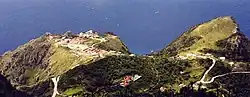 View of St Johns Village as seen from Mount Scenery | |
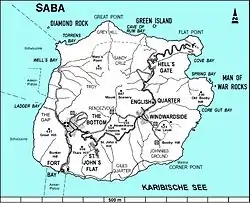 Map of Saba showing St. Johns | |
| Coordinates: 17°37′13.36″N 63°14′35.1″W / 17.6203778°N 63.243083°W | |
| Country | |
| Public body | |
| Population (2001)[1] | |
| • Total | 186 |
| Time zone | UTC-4 (AST) |
St. Johns is the smallest settlement on Saba[2] and is located between The Bottom and Windwardside. It was the birthplace of Cornelia Jones.[3]
Geography
St. Johns is primarily a residential area, but also contains both schools on the island, the Sacred Heart School (primary education) and Saba Comprehensive School (secondary education).
Sights
Attached to the Sacred Heart School is a small chapel that is run by Father Janssen. It is common to see the chapel used by the school on weekdays for religious class and on Sunday for mass.
See also
References
- ↑ "Geodata 2001, Saba & Sint.Eustatius, Census 2001". Centraal Bureau voor de Statistiek, Netherlands Antilles. 2001. p. 17. Retrieved 3 May 2021.
- ↑ The villages of Saba (Saba Tourist Bureau)
- ↑ Johnson, Will (15 August 2009). "Under the Sea Grape Tree: Miss Cornelia Jones First Woman Member of the Island Council" (PDF). The Daily Herald. Philipsburg, St. Maarten. Archived from the original (PDF) on 5 November 2017. Retrieved 4 November 2017.
External links
![]() Media related to St. Johns at Wikimedia Commons
Media related to St. Johns at Wikimedia Commons
| Populated places | |||
|---|---|---|---|
| Other locations | |||
| Transport | |||
| Education | |||
| Heraldry | |||
| Culture | |||
This article is issued from Wikipedia. The text is licensed under Creative Commons - Attribution - Sharealike. Additional terms may apply for the media files.