Tübingen | |
|---|---|
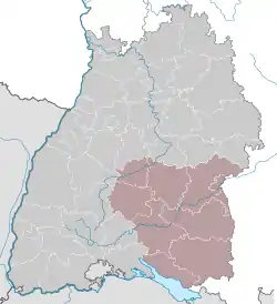 Map of Baden-Württemberg highlighting Tübingen | |
| Country | Germany |
| State | Baden-Württemberg |
| Region seat | Tübingen |
| Area | |
| • Total | 8,917.82 km2 (3,443.19 sq mi) |
| Population (31 December 2021)[1] | |
| • Total | 1,876,055 |
| • Density | 210/km2 (540/sq mi) |
| GDP | |
| • Total | €88.301 billion (2021) |
| Website | https://rp.baden-wuerttemberg.de/rpt/Seiten/default.aspx |
Tübingen is one of the four Administrative Regions (Regierungsbezirke) of Baden-Württemberg, Germany, located in the south-east of the state. It covers most of the German shore of Lake Constance (Bodensee), and also the beginning of the Danube River valley. It is sub-divided into the three regions (Regionalverband): Neckar-Alb, Donau-Iller and Bodensee-Oberschwaben. Donau-Iller also includes three districts and one city of Bavaria.
| Kreise (districts) |
Kreisfreie Städte (district-free towns) |
|---|---|
Economy
The gross domestic product (GDP) of the region was €80.8 billion in 2018, accounting for 2.4% of German economic output. GDP per capita adjusted for purchasing power was €40,100 or 133% of the EU27 average in the same year. The GDP per employee was 108% of the EU average. This makes it one of the wealthiest regions in Germany and Europe.[3]
References
- ↑ "Bevölkerung nach Nationalität und Geschlecht am 31. Dezember 2021" [Population by nationality and sex as of December 31, 2021] (CSV) (in German). Statistisches Landesamt Baden-Württemberg. June 2022.
- ↑ "EU regions by GDP, Eurostat". Retrieved 18 September 2023.
- ↑ "Regional GDP per capita ranged from 30% to 263% of the EU average in 2018". Eurostat.
External links
Administrative regions (Regierungsbezirk) in Baden-Württemberg | |||
|---|---|---|---|