Takalar Regency
Kabupaten Takalar | |
|---|---|
 Coat of arms | |
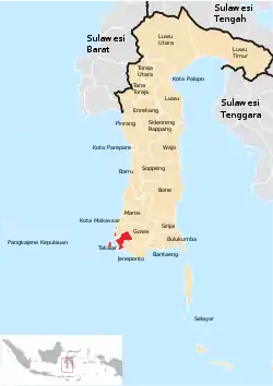 Location within South Sulawesi | |
| Country | Indonesia |
| Province | South Sulawesi |
| Capital | Pattallassang |
| Area | |
| • Total | 566.51 km2 (218.73 sq mi) |
| Population (mid 2022 estimate)[1] | |
| • Total | 305,077 |
| • Density | 540/km2 (1,400/sq mi) |
| Time zone | UTC+8 (WITA) |
Takalar Regency (Makasar: ᨈᨀᨒᨑ, romanized: Takalara’, Makasar pronunciation: [taˈkalaraʔ]) is a regency of South Sulawesi Province, Indonesia. It covers an area of 566.51 km2 and had a population of 269,603 at the 2010 census[2] and 300,853 at the 2020 census;[3] the official estimate for mid 2022 was 305,077 (comprising 149,066 males and 156,011 females).[1] The entire regency lies within the official metropolitan area of the city of Makassar (the metropolitan area is known as Mamminasata). The principal towns are at Galesong and Takalar, but the administrative centre is at Pattallassang.
Administrative division
At the 2010 census the regency was divided into nine districts (Indonesian: kecamatan), but a tenth district (Kepulauan Tanakeke) was subsequently cut out of Mappakusunggu District. These districts are tabulated below with their areas and their population totals from the 2010 census[2] and the 2020 census,[3] together with the official estimates for mid 2022.[1] Two additional districts were subsequently added in late 2022 - Polombangkeng Timur cut out from part of Polombangkeng Utara District, and Laikang from part of Mangarabombang District; no separate figures are yet available for their areas and populations, which are included with the figures for the district from which they were cut out. The table also includes the locations of the district administrative centres, the number of villages in each district (totaling 86 rural desa and 24 urban kelurahan), and its postal codes.
| Kode Wilayah | Name of District (kecamatan) | Area in km2 | Pop'n census 2010 | Pop'n census 2020 | Pop'n Estimate mid 2022 | Admin centre | No. of villages | Post codes |
|---|---|---|---|---|---|---|---|---|
| 73.05.02 | Mangarabombang | 100.50 | 36,689 | 41,085 | 41,688 | Mangadu | 6 (a) | 92261 |
| 73.05.12 | Laikang | 6 | 92261 | |||||
| 73.05.01 | Mappakusunggu | 15.12 | 15,139 | 9,461 | 9,541 | Cilallang | 4 (a) | 92232 |
| 73.05.08 | Sanrobone | 29.36 | 13,276 | 15,257 | 15,559 | Sanrobone | 6 | 92231 |
| 73.05.10 | Kepulauan Tanakeke (b) (Tanakeke Islands) | 30.15 | (c) | 6,984 | 7,045 | Maccini Baji | 6 | 92232 |
| 73.05.03 | Polombangkeng Selatan (South Polombangkeng) | 88.07 | 26,754 | 29,237 | 29,526 | Bulukunyi | 11 (d) | 92252 |
| 73.05.07 | Pattallassang | 25.31 | 34,729 | 39,275 | 39,928 | Pattallassang | 9 (e) | 92211 |
| 73.05.04 | Polombangkeng Utara (North Polombangkeng) | 212.25 | 45,825 | 50,255 | 50,788 | Palleko | 10 (d) | 92221 |
| 73.05.11 | Polombangkeng Timur (East Polombangkeng) | 8 | 92221 | |||||
| 73.05.05 | Galesong Selatan (South Galesong) | 24.71 | 23,854 | 26,985 | 27,435 | Bonto Kassi | 13 | 92254 |
| 73.05.09 | Galesong (f) | 25.93 | 37,371 | 41,003 | 41,441 | Galesong Kota | 17 | 92254 & 92255 |
| 73.05.06 | Galesong Utara (North Galesong) | 15.11 | 35,966 | 41,311 | 42,124 | Bonto Lebang | 14 (a) | 92255 |
| Totals | 566.51 | 269,603 | 300,853 | 305,077 | Pattallassang | 110 |
Notes: (a) includes one kelurahan. (b) comprises a group of eight offshore islands. (c) the 2010 figure is included in the figure for Mappakusunggu District. (d) includes 6 kelurahan. (e) all 9 are kelurahan. (f) includes offshore island of Pulau Sanrobengi.
The regency is virtually split into two parts, with part of Gowa Regency nearly reaching the coast between Galesong Selatan and Sanrobone districts. The northern part (the three Galesong districts) forms an urbanised narrow coastal strip stretching south from Makassar city, plus the small offshore island of Pulau Sanrobengi; it covers 65.75 km2 with 111,000 inhabitants in mid 2022.[1] The larger southern area comprises the remaining nine districts.
References
Regencies and cities of South Sulawesi | ||
|---|---|---|
Capital: Makassar | ||
| Regencies |  | |
| Cities | ||
5°25′S 119°35′E / 5.417°S 119.583°E