Taksar
टक्सार | |
|---|---|
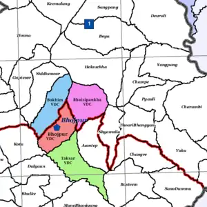
 Map of Bhojpur Municipality before 2017 showing Taksar VDC as neighborhood | |
 Taksar Location in Nepal  Taksar Taksar (Nepal) | |
| Coordinates: 27°09′26″N 87°03′04″E / 27.15722°N 87.05111°E | |
| Country | |
| Provinces | Province No. 1 |
| District | Bhojpur District |
| Municipalities | Bhojpur Municipality |
| Established | 2017 |
| Government | |
| • Type | Ward council |
| • Body | Bhojpur Municipality |
| • Chairperson | Kumar Prasad Shrestha |
| Area | |
| • Total | 2,072 km2 (800 sq mi) |
| Population (2011) | |
| • Total | 3,350 |
| • Density | 1.6/km2 (4.2/sq mi) |
| Time zone | UTC+5:45 (Nepal Time) |
Taksar is a former VDC and now a neighborhood of Bhojpur Municipality in Bhojpur District in Province No. 1 of eastern Nepal. At the time of the 1991 Nepal census, Taksar had a population of 4,524 persons living in 829 individual households.[1]
On 18 May 2014, the Government of Nepal announced the establishment of seventy-two new municipalities across the country.[2] At this time, Bhojpur Municipality was established, incorporating Bhojpur, Bhaisipankha, Bokhim and Taksar VDCs, subdivided into eleven wards.
According to the 2011 Nepal census, 3,350 individuals live in Taksar and it covers an area of 20.72 square kilometres (8.00 sq mi). It is now Ward No. 12 of Bhojpur Municipality. [3]
| Neighborhood | Ward no. | Area | Population (2011) | Ward chairperson |
|---|---|---|---|---|
| Taksar | 12 | 20.72 KM² | 3,350 | Kumar Prasad Shrestha |
References
- ↑ "Nepal Census 2001". Nepal's Village Development Committees. Digital Himalaya. Archived from the original on 12 October 2008. Retrieved 12 September 2008.
- ↑ "Government announces 72 new municipalities". The Kathmandu Post. Retrieved 2014-06-10.
- ↑ "District Corrected Last for RAJAPATRA" (PDF). www.mofald.gov.np. Retrieved 17 July 2018.
External links
This article is issued from Wikipedia. The text is licensed under Creative Commons - Attribution - Sharealike. Additional terms may apply for the media files.