Takum | |
|---|---|
LGA and town | |
| Nickname: TTM | |
| Motto: Together We are One | |
| Coordinates: 7°15′N 9°59′E / 7.250°N 9.983°E | |
| Country | |
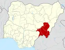
| State | Taraba State |
| Local Government Headquarters | Takum |
| Government | |
| • Chairman | Hon.Boyi manja [CTC] |
| Area | |
| • Total | 2,503 km2 (966 sq mi) |
| Population (2006 census) | |
| • Total | 135,349 |
| Time zone | UTC+1 (WAT) |
| 3-digit postal code prefix | 671 |
| ISO 3166 code | NG.TA.TA |
Takum is a Local Government Area in Taraba State, Nigeria. Its headquarters is in the town of Takum, it is created out of Wukari local government in June 1976, at 7°16′00″N 9°59′00″E / 7.26667°N 9.98333°E. Takum borders the Republic of Cameroon in the south, Ussa Local Government to the west, Donga Local government to the north, District within Takum are Angwan Dutse, Angwa Abuja, Tikari, Fadama, Gahwetun, Akenten, Acha Nyim, Chanchanji (Peva), Sufa, Shimta, Kufi, Muji, Akenten, Lufu, Kashimbilla, Kpaasan, Likam, Bete, Malumshe, Jidu, Tampwa, Dumse, Nyayirim, Barki Lissa,Acha Sarka, Sabon Gida Yukuben etc.
Major tribes are Kuteb, Ichen, Kpanzon, Tiv, Chamba and Hausa, Takum is under the Traditional leadership of the Ukwe Takum dating back to the 16th century.
THE UKWE
The Ukwe is the Supreme Head of the Kutebland. In the proceeds of time as already ordain by KUTEB himself, this position is reserved for the Likam and Akente, which eventually appears that the value attached to seniority in Kuteb culture accounts for the retention of certain superiority by the Likam, and Akente the next most senior and neighbouring clan to Likam by being the source of the two royal families of Takum for the stool of Ukwe Takum. Even in modern Politics and Government, the seniority factor among the Kutebs still accounts for the need to consult the elders before final decisions are taken and acted upon.
Below is the list of Takum Traditional rulers since 1500 AD.
| Ukwe Likam Kuteb I | 1510-1550 | |
| Ukwe Rucwu Acha I | 1550-1600 | |
| Ukwe Kuteb Riyang II | 1600-1645 | |
| Ukwe Ajunkwe Acebuy | 1645-1695 | |
| Ukwe Andeburga Ricwu Acha | 1695-1730 | |
| Ukwe Kingham Gankwe I | 1730-1775 | |
| Ukwe Ganza Kwetsa | 1775-1815 | |
| Ukwe Atirikwe | 1815-1855 | |
| Ukwe Ayipte Gayara | 1855-1890 | |
| Ukwe Ribon Ipop Gamina | 1890-1912 | |
| Ukwe Ahmadu Gankwe | 1912-1926 | |
| Ukwe Hassan A Gankwe | 1926-1929 | |
| Ukwe Ibrahim Kufang | 1929-1938 | |
| Ukwe Audu Gyaa Ahmadu Kufang II | 1938-1963 | |
| Ukwe Ali Ibrahim | 1963-1996 |
- Takum
- It has an area of 2,503 km2 and a population of 135,349 at the 2006 census.The postal code of the area is 671.[1]
Climate
Takum, a tropical wet and dry climate, has a yearly temperature of 31.41oC (88.54oF), which is 1.95% higher than Nigeria's norms.[2][3][4]
Languages
Takum is highly linguistically diverse, with more than a dozen distinct local languages (mostly Jukunoid languages and Southern Bantoid languages).[5]
- Kuteb language (Nigeria)|kuteb language]]
- Hausa
- Kpan language
- Acha Language
- Tiv language
References
- ↑ "Post Offices- with map of LGA". NIPOST. Archived from the original on 7 October 2009. Retrieved 20 October 2009.
- ↑ "Takum, Taraba, NG Climate Zone, Monthly Averages, Historical Weather Data". tcktcktck.org. Retrieved 14 September 2023.
- ↑ Atlas, Weather. "Yearly & Monthly weather - Takum, Nigeria". Weather Atlas. Retrieved 14 September 2023.
- ↑ "Takum, Taraba, Nigeria 10-Day Weather Forecast - The Weather Channel | Weather.com". The Weather Channel. Retrieved 14 September 2023.
- ↑ Languages of Nigeria (Ethnologue 22nd edition)