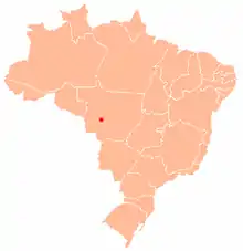
Approximate location of Tapirapuã
Tapirapuã is a village in the municipality of Barra do Bugres in Mato Grosso, Brazil. It is in the mountainous Serra do Tapirapuã region and next to Sepotuba River.
History
In the early 20th century, Cândido Mariano da Silva Rondon established a warehouse for his telegraph commission in Tapirapuã which was supplied by motorized boats.[1]
See also
References
- ↑ Diacon, Todd A. (2004). Stringing together a nation : Candido Mariano da Silva Rondon and the construction of a modern Brazil, 1906-1930. Durham: Duke University Press. p. 22. ISBN 0822332108. OCLC 52429358.
15°06′S 57°41′W / 15.100°S 57.683°W
This article is issued from Wikipedia. The text is licensed under Creative Commons - Attribution - Sharealike. Additional terms may apply for the media files.