Tedieville, Missouri | |
|---|---|
 Tedieville, Missouri | |
| Coordinates: 38°55′12″N 93°16′20″W / 38.92000°N 93.27222°W | |
| Country | |
| State | |
| County | Pettis County |
| Township | Longwood Township |
| Elevation | 245 m (804 ft) |
| Time zone | UTC-6 (Central (CST)) |
| • Summer (DST) | UTC-5 (CDT) |
| ZIP code | 65333 |
| GNIS feature ID | 737947[1] |
Tedieville was an unincorporated community in northern Pettis County, Missouri, United States.[1]
The community was located on Missouri Route CC approximately 4.5 miles northeast of Houstonia and one mile south of the Pettis-Saline county line.[2]
History
A post office called Tedieville was established in 1887, and remained in operation until 1903.[3] It is unknown why the name "Tedieville" was applied to this community.[4]
References
- 1 2 3 U.S. Geological Survey Geographic Names Information System: Tedieville, Missouri
- ↑ Sweet Springs, MO 15 Minute Topographic Quadrangle, USGS, 1945
- ↑ "Post Offices". Jim Forte Postal History. Retrieved November 27, 2016.
- ↑ "Pettis County Place Names, 1928–1945". The State Historical Society of Missouri. Archived from the original on June 24, 2016. Retrieved November 27, 2016.
Municipalities and communities of Pettis County, Missouri, United States | ||
|---|---|---|
| Cities | 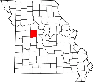 Map of Missouri highlighting Pettis County | |
| Villages | ||
| Townships | ||
| Unincorporated communities | ||
| Ghost towns | ||
| Footnotes | ‡This populated place also has portions in an adjacent county or counties | |
This article is issued from Wikipedia. The text is licensed under Creative Commons - Attribution - Sharealike. Additional terms may apply for the media files.