| Théniet El Had National Park | |
|---|---|
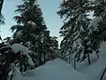
 Inside a forest within the park | |
| Highest point | |
| Peak | Ras el Braret |
| Elevation | 1,787 m (5,863 ft) |
| Geography | |
| Country | Algeria |
 EL MEDDAD National Park in Algeria | |
| Location | Tissemsilt Province, Algeria |
| Nearest city | Théniet El Haâd |
| Coordinates | 35°40′N 01°49′E / 35.667°N 1.817°E |
| Area | 36.16 km2 (13.96 sq mi) |
| Established | 1983 (Protected from 1929) |
The Théniet El Had National Park is one of the 10 national parks of Algeria. It is located in Tissemsilt Province, named after Théniet El Haâd, a town near this park.
Description
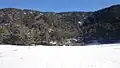
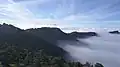
It has several forests, and it is located in the foothills of the highest peak (1.985 meter/ 6.512 feet high) of the Ouarsenis mountain chain in the Tell Atlas; home to a diversified flora and fauna. The park is a popular hiking destination for many Algerians.
Seventeen species of mammals live in the park, nine of which are protected, also 27 bird species live here, of which 60% are actively breeding here.[1]
Vegetation

The forested sector occupies roughly 3/4 of the park area, while the rest is made up of small ground-level plants. Three distinct layers can be distinguished from each other:[2]
- Trees:
- Atlas cedar (Cedrus atlantica): On the southern side of the park, a mixture of both modern and ancient cedars is present, with 10 to 20% being the Atlas cedar.
- Cork oak (Quercus suber).
- Pine.
- Trees that are between 2 meters and 7 meters tall in the layer are a mix of species:
- Holm oak (Quercus ilex) can be found on the northern side.
- Cade (Juniperus oxycedrus) can be found on the southern side.
- Gall oak (Quercus lusitanica) can also be found on the southern side.
- Grass & flowers:
- Alexanders (Smyrnium olusatrum).
- Geranium atlanticum.
- Viola.
- Common ivy (Hedera helix).
- Chrysanthemum.
Gallery

_20.JPG.webp)
_10.JPG.webp)


References
- ↑ "Explore Algeria's Théniet El Had National Park". Algeria.com. Retrieved 2021-02-16.
- ↑ "Parc National de Théniet El Had: Flore". web.archive.org. Retrieved 2023-12-30.
External links
- (in French) Official Website
- (in French) Official website
- Park data on UNEP-WPMC