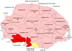
 Position within Norfolk, 1894 Boundaries in 1894. 1902 extension in yellow |
Thetford Rural District was a rural district in Norfolk, England from 1894 to 1935.[1]
It was formed under the Local Government Act 1894 based on the Thetford rural sanitary district. It covered the lands which were in Norfolk and lay to the north and east of Thetford Municipal Borough.
In 1902 it took in the western part of the disbanded Guiltcross Rural District,[2].
In 1935, Thetford RD was abolished and its territory divided between Downham, Swaffham and Wayland RDs.
Statistics
| Year | Area (ha) [3] |
Population [4] |
Density (pop/ha) |
|---|---|---|---|
| 1911 | 38,799 | 14,425 | 0.37 |
| 1921 | 13,121 | 0.34 | |
| 1931 | 13,150 | 0.34 |
Parishes
| Parish | From | To | Notes |
|---|---|---|---|
| Blo' Norton | 1902 | Formerly Guiltcross RD. To Wayland RD | |
| Brandon | 1902 | Formerly Guiltcross RD. To Wayland RD | |
| Brettenham | To Wayland RD | ||
| Bridgham | 1902 | Formerly Guiltcross RD. To Wayland RD | |
| Cranwich | To Swaffham RD | ||
| Croxton | To Wayland RD | ||
| East Harling | 1902 | Formerly Guiltcross RD. | |
| East Wretham | 1902 | To Wayland RD | |
| Feltwell | To Downham RD | ||
| Feltwell Anchor | 1929 | Added to Feltwell | |
| Garboldisham | 1902 | Formerly Guiltcross RD. To Wayland RD | |
| Gasthorpe | 1902 | Formerly Guiltcross RD. | |
| Great and Little Snarehill | To Wayland RD (with Brettenham) | ||
| Hockwold cum Wilton | To Downham RD | ||
| Kilverstone | To Wayland RD | ||
| Lynford | To Swaffham RD | ||
| Methwold | To Downham RD | ||
| Mundford | To Swaffham RD | ||
| North Lopham | 1902 | Formerly Guiltcross RD. To Wayland RD | |
| Northwold | To Downham RD | ||
| Riddlesworth | 1902 | Formerly Guiltcross RD. To Wayland RD | |
| Rushford | To Wayland RD (with Brettenham) | ||
| Santon | To Swaffham RD | ||
| South Lopham | 1902 | Formerly Guiltcross RD. To Wayland RD | |
| Sturston | To Swaffham RD | ||
| Weeting with Broomhill | To Swaffham RD | ||
| West Harling | 1902 | Formerly Guiltcross RD. | |
| West Tofts | To Swaffham RD | ||
| West Wretham | To Wayland RD |
References
- ↑ "Thetford RD through time: Census tables with data for the Local Government District". A Vision of Britain through Time. GB Historical GIS / University of Portsmouth. Retrieved 29 June 2017.
- ↑ "Garboldisham CP/AP through time: Census tables with data for the Parish-level Unit". A Vision of Britain through Time. GB Historical GIS / University of Portsmouth. This change is not reported on the District level pages, but is apparent from parish commencement dates. Retrieved 29 June 2017.
- ↑ "Thetford RD through time: Population Statistics: Area (acres)". A Vision of Britain through Time. GB Historical GIS / University of Portsmouth. Retrieved 29 June 2017.
- ↑ "Thetford RD through time: Population Statistics: Total Population". A Vision of Britain through Time. GB Historical GIS / University of Portsmouth. Retrieved 29 June 2017.
This article is issued from Wikipedia. The text is licensed under Creative Commons - Attribution - Sharealike. Additional terms may apply for the media files.