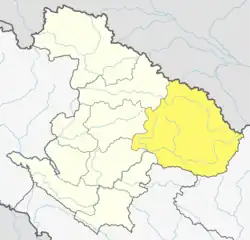
Thuli Bheri
ठुली भेरी | |
|---|---|
 Thuli Bheri Location in Nepal | |
| Coordinates: 28°56′00″N 82°54′00″E / 28.933333°N 82.9°E | |
| Country | |
| Province | Karnali |
| District | Dolpa |
| No. of wards | 11 |
| Established | 10 March 2017 |
| Government | |
| • Type | Mayor-council |
| • Mayor | Mr. Ganesh Bahadur Shahi (NCP) |
| • Deputy mayor | Mr. Yogendra Bahaduri Shahi (RPP) |
| Area | |
| • Total | 421.34 km2 (162.68 sq mi) |
| Population (2011) | |
| • Total | 8,370 |
| • Density | 20/km2 (51/sq mi) |
| Time zone | UTC+5:45 (NST) |
| Website | official website |
Thuli Bheri (Nepali: ठुली भेरी) is an urban municipality located in Dolpa District of Karnali Province of Nepal.[1] The district headquarter of Dolpa lies in Dunai, which is a village in the south-east of Thuli Beri.
The total area of the municipality is 421.34 square kilometres (162.68 sq mi) and the total population of the municipality as of 2011 Nepal census is 8,370 individuals. The municipality is divided into total 11 wards.[2]
History
The municipality was established on 10 March 2017, when Government of Nepal restricted all old administrative structure and announced 744 local level units as per the new constitution of Nepal 2015.[3][4]
Dunai, Majhphal, Juphal and Raha Village development committees were incorporated to form this new municipality. The headquarters of the municipality is situated at Dunai.[2]
Demographics
At the time of the 2011 Nepal census, 96.7% of the population in Thuli Bheri Municipality spoke Nepali, 0.8% Bote, 0.6% Magar, 0.6% Sherpa, 0.2% Maithili, 0.2% Gurung, 0.1% Tamang and 0.1% Urdu as their first language; 0.7% spoke other languages.
In terms of ethnicity/caste, 67.4% were Chhetri, 11.0% Thakuri, 9.5% Kami, 2.6% Hill Brahmin, 2.4% Sarki, 2.2% Magar, 1.8% Damai/Dholi, 0.9% Tamang, 0.7% Gurung and 1.5% others.
In terms of religion, 97.4% were Hindu, 2.4% Buddhist, 0.2% Muslim and 0.1% Christian.[5]
Transportation
Dolpa Airport lies Old-Juphal, in the north-west of the town and offers flights to Nepalgunj.[6]
Education
In education, there is the Dolpa Campus affiliated with Tribhuvan University, one high school: Sarswoti Higher Secondary School affiliated with HSEB, and the Dunai Community Library which is a community learning center.
Healthcare
There is one hospital, the 15-bed Dolpa District Hospital.
References
- ↑ "स्थानीय तहहरुको विवरण" [Details of the local level bodies]. www.mofald.gov.np/en (in Nepali). Ministry of Federal Affairs and Local Development. Retrieved 17 July 2018.
- 1 2 "District Corrected Last for RAJAPATRA" (PDF). www.mofald.gov.np. Retrieved 17 July 2018.
- ↑ "New local level structure comes into effect from today". www.thehimalayantimes.com. The Himalayan Times. 10 March 2017. Retrieved 17 July 2018.
- ↑ "New local level units come into existence". www.kathmandupost.ekantipur.com. 11 March 2017. Retrieved 18 July 2018.
- ↑ NepalMap Demographics
- ↑ "Dolpa Airport" (PDF). Civil Aviation authority of Nepal. Retrieved 1 October 2018.
