Tierralta | |
|---|---|
Municipality and town | |
.svg.png.webp) Flag | |
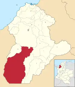
 Location of the municipality and town of Tierralta in the Córdoba Department of Colombia. | |
| Country | |
| Department | Córdoba Department |
| Area | |
| • Municipality and town | 4,938 km2 (1,907 sq mi) |
| • Urban | 7.99 km2 (3.08 sq mi) |
| Elevation | 51 m (167 ft) |
| Population (2020 est.)[1] | |
| • Municipality and town | 95,177 |
| • Density | 19/km2 (50/sq mi) |
| • Urban | 43,553 |
| • Urban density | 5,500/km2 (14,000/sq mi) |
| Time zone | UTC-5 (Colombia Standard Time) |
Tierralta is a town and municipality located in the Córdoba Department, northern Colombia.
According to 2020 estimates, the population of Tierralta was 95,177, with a population density of 19 persons per square kilometer.
Corregimientos
- Callejas
- Crucito
- Palmira
- Santa Fé de Ralito
- Caramelo
- San Clemente
- Las Claras
- Saiza
- Frasquillo
- Volador
- El Toro
- San Felipe de Cadillo
- Batata
- Tucurá
- Nueva Granada
- Santa Marta
- Villa Providencia
- Carrizola
- Urra Campo Bello
- Nuevo Oriente
References
- ↑ Citypopulation.de Population of Tierralta municipality
- (in Spanish) Gobernacion de Cordoba - Tierralta
- (in Spanish) Tierralta official website
This article is issued from Wikipedia. The text is licensed under Creative Commons - Attribution - Sharealike. Additional terms may apply for the media files.