Tourouvre | |
|---|---|
Part of Tourouvre au Perche | |
 Saint-Aubin church | |
Location of Tourouvre | |
 Tourouvre  Tourouvre | |
| Coordinates: 48°35′28″N 0°39′08″E / 48.5911°N 0.6522°E | |
| Country | France |
| Region | Normandy |
| Department | Orne |
| Arrondissement | Mortagne-au-Perche |
| Canton | Tourouvre (chef-lieu) |
| Commune | Tourouvre au Perche |
| Area 1 | 24.01 km2 (9.27 sq mi) |
| Population (2019)[1] | 1,519 |
| • Density | 63/km2 (160/sq mi) |
| Time zone | UTC+01:00 (CET) |
| • Summer (DST) | UTC+02:00 (CEST) |
| Postal code | 61190 |
| Elevation | 180–304 m (591–997 ft) (avg. 236 m or 774 ft) |
| 1 French Land Register data, which excludes lakes, ponds, glaciers > 1 km2 (0.386 sq mi or 247 acres) and river estuaries. | |
Tourouvre (French pronunciation: [tuʁuvʁ] ⓘ) is a former commune in the Orne department in north-western France. On 1 January 2016, it was merged into the new commune of Tourouvre au Perche.[2]
The first photovoltaic road in the world was under construction in Tourouvre in November–December 2016.[3] It was built by Société Nouvelle Aeracem (SNA), and dedicated by the French Minister of Ecology, Ségolène Royal on 25 October 2016.[3] In 2019, Le Monde declared the experiment a failure.[4]
Heraldry
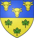
 Arms of Tourouvre |
The arms of Tourouvre are blazoned : Per fess, azure and Or, 3 ox heads Or and 3 maple leaves vert.
|
See also
References
- ↑ Téléchargement du fichier d'ensemble des populations légales en 2019, INSEE
- ↑ Arrêté préfectoral 21 December 2015 (in French)
- 1 2 Bourgin, Yohann (October 25, 2016). "High Tech. Ségolène Royal lance la première route solaire dans l'Orne". Sud-Ouest. Retrieved November 2, 2016.
- ↑ "En Normandie, le fiasco de la plus grande route solaire du monde". Le Monde.fr. 22 July 2019.
Wikimedia Commons has media related to Tourouvre.
This article is issued from Wikipedia. The text is licensed under Creative Commons - Attribution - Sharealike. Additional terms may apply for the media files.