Trimiklini
Τριμίκλινη | |
|---|---|
 | |
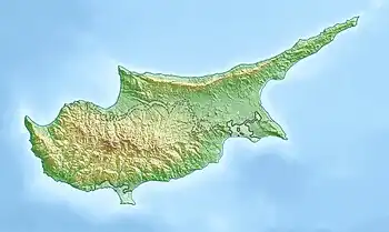
 Trimiklini Location in Cyprus | |
| Coordinates: 34°50′49″N 32°54′42″E / 34.84694°N 32.91167°E | |
| Country | |
| District | Limassol District |
| Population (2021)[1] | |
| • Total | 353 |
| Time zone | UTC+2 (EET) |
| • Summer (DST) | UTC+3 (EEST) |
| Website | http://www.trimiklini.org.cy |

Double Bridge in Trimiklini.
Trimiklini (Greek: Τριμίκλινη) is a village in the Limassol District of Cyprus, located 9 km south of Pano Platres.

church Panayias Eleousis
Climate
| Climate data for Saittas near Trimiklini, elevation: 640 m (Satellite view) | |||||||||||||
|---|---|---|---|---|---|---|---|---|---|---|---|---|---|
| Month | Jan | Feb | Mar | Apr | May | Jun | Jul | Aug | Sep | Oct | Nov | Dec | Year |
| Mean daily maximum °C (°F) | 13.6 (56.5) |
13.9 (57.0) |
17.1 (62.8) |
21.5 (70.7) |
27.0 (80.6) |
31.5 (88.7) |
34.6 (94.3) |
34.1 (93.4) |
31.2 (88.2) |
26.8 (80.2) |
20.2 (68.4) |
15.2 (59.4) |
23.9 (75.0) |
| Daily mean °C (°F) | 8.4 (47.1) |
8.5 (47.3) |
10.9 (51.6) |
14.8 (58.6) |
19.6 (67.3) |
23.8 (74.8) |
26.8 (80.2) |
26.5 (79.7) |
23.4 (74.1) |
19.7 (67.5) |
14.1 (57.4) |
10.0 (50.0) |
17.2 (63.0) |
| Mean daily minimum °C (°F) | 3.2 (37.8) |
3.1 (37.6) |
4.7 (40.5) |
8.0 (46.4) |
12.2 (54.0) |
16.1 (61.0) |
18.9 (66.0) |
18.7 (65.7) |
15.7 (60.3) |
12.5 (54.5) |
8.1 (46.6) |
4.7 (40.5) |
10.5 (50.9) |
| Average precipitation mm (inches) | 117.6 (4.63) |
89.0 (3.50) |
70.3 (2.77) |
38.4 (1.51) |
20.1 (0.79) |
27.2 (1.07) |
4.9 (0.19) |
10.3 (0.41) |
11.7 (0.46) |
25.7 (1.01) |
93.9 (3.70) |
144.0 (5.67) |
653.2 (25.72) |
| Average precipitation days (≥ 1 mm) | 10.3 | 9.1 | 8.4 | 5.5 | 2.7 | 2.1 | 0.7 | 1.1 | 1.4 | 3.3 | 7.0 | 9.2 | 60.9 |
| Mean monthly sunshine hours | 142.6 | 168.2 | 213.9 | 261.0 | 310.0 | 351.0 | 362.7 | 347.2 | 300.0 | 248.0 | 165.0 | 124.0 | 2,993.6 |
| Source: Meteorological Service (Cyprus)[2] | |||||||||||||
References
This article is issued from Wikipedia. The text is licensed under Creative Commons - Attribution - Sharealike. Additional terms may apply for the media files.
