Trokavec | |
|---|---|
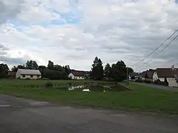 Centre of Trokavec | |
 Flag  Coat of arms | |
 Trokavec Location in the Czech Republic | |
| Coordinates: 49°38′49″N 13°42′8″E / 49.64694°N 13.70222°E | |
| Country | |
| Region | Plzeň |
| District | Rokycany |
| First mentioned | 1545 |
| Area | |
| • Total | 4.39 km2 (1.69 sq mi) |
| Elevation | 615 m (2,018 ft) |
| Population (2023-01-01)[1] | |
| • Total | 121 |
| • Density | 28/km2 (71/sq mi) |
| Time zone | UTC+1 (CET) |
| • Summer (DST) | UTC+2 (CEST) |
| Postal code | 338 43 |
| Website | trokavec |
Trokavec is a municipality and village in Rokycany District in the Plzeň Region of the Czech Republic. It has about 100 inhabitants.
Geography
Trokavec is located about 13 km (8 mi) southeast of Rokycany and 23 km (14 mi) southeast of Plzeň. It lies on the border between the Brdy Highlands and Švihov Highlands. The highest point is the hill Trokavecká skála at 706 m (2,316 ft) above sea level.
References
External links
Wikimedia Commons has media related to Trokavec.
This article is issued from Wikipedia. The text is licensed under Creative Commons - Attribution - Sharealike. Additional terms may apply for the media files.