Tureta | |
|---|---|
LGA and town | |
 Tureta | |
| Coordinates: 12°35′22″N 5°32′49″E / 12.58944°N 5.54694°E | |
| Country | |
| State | Sokoto State |
| Area | |
| • Total | 920 sq mi (2,383 km2) |
| Population (2006) | |
| • Total | 68,370 |
| Time zone | UTC+1 (WAT) |
| 3-digit postal code prefix | 852 |
| ISO 3166 code | NG.OG.TT |
Tureta is a Local Government Area in Sokoto State, Nigeria. Its headquarters is in the town of Tureta. It shares a border with Zamfara State in the south and east. They are mainly Hausa people predominantly Burmawa. Islam is there main religion. Fishing and farming are the major occupations. Currently Dr Muhammad Danrabi Tureta is their newly appointed king title as sarkin Burmin tureta.
Tureta has an area of 2,383 km2 and a population of 68,370 at the 2006 census.[1]
The postal code of the area is 852.[2]
Climate
The average temperature ranges from 62°F to 103°F, with the wet season being hot, oppressive, and mostly cloudy, and the dry season being hot and partly cloudy.[3][4][5]
References
- ↑ HASC, population, area and Headquarters Statoids
- ↑ "Post Offices- with map of LGA". NIPOST. Archived from the original on 2009-10-07. Retrieved 2009-10-20.
- ↑ "Tureta Climate, Weather By Month, Average Temperature (Nigeria) - Weather Spark". weatherspark.com. Retrieved 2023-09-01.
- ↑ "Tureta, Sokoto, NG Climate Zone, Monthly Averages, Historical Weather Data". tcktcktck.org. Retrieved 2023-09-01.
- ↑ "Tureta, Sokoto, Nigeria - City, Town and Village of the world". en.db-city.com. Retrieved 2023-09-01.
State capital: Sokoto | ||
| Local Government Areas | 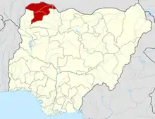 | |
This article is issued from Wikipedia. The text is licensed under Creative Commons - Attribution - Sharealike. Additional terms may apply for the media files.