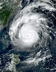
 Muifa at peak intensity while east of Taiwan on September 11 | |
| Meteorological history | |
|---|---|
| Formed | September 3, 2022 |
| Extratropical | September 16, 2022 |
| Dissipated | September 17, 2022 |
| Very strong typhoon | |
| 10-minute sustained (JMA) | |
| Highest winds | 155 km/h (100 mph) |
| Lowest pressure | 950 hPa (mbar); 28.05 inHg |
| Category 3-equivalent typhoon | |
| 1-minute sustained (SSHWS/JTWC) | |
| Highest winds | 205 km/h (125 mph) |
| Lowest pressure | 946 hPa (mbar); 27.94 inHg |
| Overall effects | |
| Fatalities | 3 total |
| Missing | 2 |
| Damage | $437 million (2022 USD) |
| Areas affected |
|
| IBTrACS / [1] | |
Part of the 2022 Pacific typhoon season | |
Typhoon Muifa, known in the Philippines as Typhoon Inday, was a powerful tropical cyclone that affected East China, Taiwan, and the Ryukyu Islands in mid-September 2022. It was the twelfth named storm and fourth typhoon of the 2022 Pacific typhoon season, having originated from an invest in the Pacific Ocean.
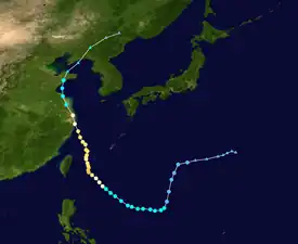
Muifa originated from a disturbance near the Philippine Sea, slowly tracking westward until its development into a tropical depression, where it began to move south westward. Muifa underwent rapid intensification as it approached eastern China, with maximum sustained winds of up to 155 km/h (95 mph) Right before its first landfall, Muifa was downgraded to a Category 3, then Muifa made its first landfall over eastern China on September 13 as a Category 1.
Meteorological history

Tropical storm (39–73 mph, 63–118 km/h)
Category 1 (74–95 mph, 119–153 km/h)
Category 2 (96–110 mph, 154–177 km/h)
Category 3 (111–129 mph, 178–208 km/h)
Category 4 (130–156 mph, 209–251 km/h)
Category 5 (≥157 mph, ≥252 km/h)
Unknown

The origins of Typhoon Muifa can be traced back to an area of disturbed weather on September 5.[2] The disturbance favorable vertical wind shear, being offset by warm sea surface temperatures of around 30–31 °C (86–88 °F).[2] A low-pressure area developed into a tropical depression, according to the Japan Meteorological Agency (JMA).[3][4] Multispectral animated satellite imagery revealed a partially exposed low-level center with deep convection to the southeastern quadrant of its disturbance.[5] At 06:00 UTC on September 6, the United States Joint Typhoon Warning Center (JTWC) issued a Tropical Cyclone Formation Alert to the exposed system.[6]
Later around the same day, the JTWC initiated advisories on the system and classified it as Tropical Depression 14W.[7] A broad low-level circulation indicate the development of a vertical hot tower over its convective.[8] Early the next day, the JTWC upgraded the depression to a tropical storm.[9] It eventually entered the Philippine Area of Responsibility (PAR) with PAGASA assigning the name Inday.[10] Deepest formative maintained with a ragged central dense overcast continued to obscure low-level circulation center.[11] By 00:00 UTC on September 8, the JMA upgraded the system to a tropical storm, assigning it the name Muifa.[12] Muifa's center was elongated due to a tropical upper tropospheric trough from the north on the system.[13] A well-defined deep convection is wrapped around the northwestern portions of the storm.[14] Muifa's convective structure continued to improve as it flared up and rotated shear.[15] microwave imaging revealed a developing, eye like-feature.[15]
The storm's quickly intensified, and was upgraded to a severe tropical storm by the JMA on September 9.[16] At 21:00 UTC that day, the JTWC also upgraded Muifa to a Category 1-equivalent typhoon, approximately 388 nautical miles (720 km; 445 mi) south of Kadena Air Base.[17] Muifa convective activity had improved overall.[17] Similarly, the JMA further upgraded Muifa to a typhoon on September 10.[18] Muifa strengthened to Category 2-equivalent typhoon after deep convection becoming more symmetric in the 24 nautical miles (44 km; 28 mi) eye.[19] Within the next three hours, the storm became a Category 3-equivalent typhoon.[20]
Satellite imagery revealed a 20 nautical miles (37 km; 23 mi) round eye with core convection in the eyewall.[21] Then, it rapidly strengthened into a Category 4-equivalent typhoon on September 11.[22] Muifa weakened back to Category 3-equivalent due to undergoing an eyewall replacement cycle.[23] At 03:00 UTC on September 12, Muifa further weakened into a Category 2-equivalent typhoon as it wrapped around the eyewall.[24] Muifa, then weakened steadily as it made landfall in Ishigaki Island.[25]
Muifa exited the PAR at 12:40 PHT (4:40 UTC) on September 13.[26][27] Satellite imagery revealed a 30 nautical miles (56 km; 35 mi) ragged eye around a convective banding.[28] A well defined system with its deep convection wrapped around it.[29] its eye structure slowly degraded.[30] At 15:00 UTC on September 14, the JTWC further downgraded it to a Category 1-equivalent typhoon.[31] The storm made landfall at this intensity on Zhoushan Island,[32] before making a second landfall in Shanghai.[33] It is the most powerful typhoon to strike Shanghai on record,[34][35] beating out the previous record of Typhoon Gloria in 1949.[36] Meanwhile, the JMA downgraded the system to a severe tropical storm by 21:00 UTC of that day.[37] At 03:00 UTC on September 15, the JTWC downgraded it to a tropical storm.[38] Muifa made third and fourth landfalls on Shandong and Liaoning.[39][40] The JMA followed suit later that day, and declaring it tropical storm.[41] Muifa continued to deteriorate as it tracked the Yellow Sea, and later dissipated late on September 16.[42]
Preparations and impact
Ryukyu Islands
Muifa caused many high waves and mudslides throughout the Ryukyu Islands. Heavy rain hit Ishigaki Island.[43]
Taiwan
Taiwan was hit by 140 km (86 mph) winds.[44] Heavy amounts of rain hit Keelung, Taipei, Hsinchu, and Taichung. The Council of Agriculture (COA) issued 15 "red alerts" and 14 "yellow alerts" for landslides throughout Northern Taiwan.[45]
China
Muifa caused much damage and heavy rainfall throughout Eastern China, most of it in towns close to the populous Yangtze River delta. Over 230 million people were affected in throughout the delta, with over 1.3 million people evacuated from Zhoushan, where powerful rain bands hit the city.[46] Muifa brought heavy rains to Shanghai, resulting in many ports near the city being closed. Ferry and shipping traffic was suspended and fishing boats were called into port. Ports near Ningbo were closed.[47]
Elsewhere
Heavy rain hit North Korea.[48]
See also
- Weather of 2022
- Tropical cyclones in 2022
- Typhoon Mamie (1985) – the only other tropical cyclone to make landfall in Shanghai at typhoon intensity.
- Typhoon Damrey (2012) – a tropical cyclone that hit the same areas as Muifa 10 years ago.
- Tropical Storm Ampil (2018) - a tropical cyclone that caused moderate damages in Shanghai and the areas that also hit by Muifa 4 years ago, it also had the same local name as of Muifa.
- Typhoon In-fa (2021) – the most recent storm to affect the Shanghai metropolitan area and East China.
- Typhoon Hinnamnor (2022) – another typhoon which took a similar southwesterly path in the Philippine Sea a few days prior to Muifa.
References
- ↑ "Q3 Global Catastrophe Recap" (PDF). Aon Benfield. Retrieved October 21, 2022.
- 1 2 Significant Tropical Weather Advisory for the Western and South Pacific Oceans, 06Z 5 September 2022 (Report). United States Joint Typhoon Warning Center. 5 September 2022. Archived from the original on 2017-12-21. Retrieved 5 September 2022. Alt URL
- ↑ Japan Meteorological Agency (September 5, 2022). WWJP27 RJTD 050600 (Warning and Weather Summary) (Report). Archived from the original on September 5, 2022. Retrieved September 5, 2022.
- ↑ Japan Meteorological Agency (September 5, 2022). WWJP27 RJTD 051200 (Warning and Weather Summary) (Report). Archived from the original on September 5, 2022. Retrieved September 5, 2022.
- ↑ Significant Tropical Weather Advisory for the Western and South Pacific Oceans, 06Z 6 September 2022 (Report). United States Joint Typhoon Warning Center. 6 September 2022. Archived from the original on 2017-12-21. Retrieved 6 September 2022. Alt URL
- ↑ Tropical Cyclone Formation Alert (Invest 91W) (Report). United States Joint Typhoon Warning Center. 6 September 2022. Archived from the original on 2022-09-06. Retrieved 6 September 2022. Alt URL
- ↑ Tropical Depression 14W (Fourteen) Warning No. 01 (Report). United States Joint Typhoon Warning Center. 6 September 2022. Archived from the original on 2022-09-07. Retrieved 6 September 2022. Alt URL
- ↑ Prognostic Reasoning for Tropical Depression 14W (Fourteen) Warning No. 02 (Report). United States Joint Typhoon Warning Center. 6 September 2022. Archived from the original on September 7, 2022. Retrieved 6 September 2022.
- ↑ Prognostic Reasoning for Tropical Storm 14W (Fourteen) Warning No. 03 (Report). United States Joint Typhoon Warning Center. 6 September 2022. Archived from the original on September 7, 2022. Retrieved 6 September 2022.
- ↑ "Tropical Cyclone Bulletin #1 for Tropical Storm 'Inday'" (PDF). PAGASA. 7 September 2022. Archived from the original (PDF) on 7 September 2022. Retrieved 7 September 2022. Alt URL
- ↑ Prognostic Reasoning for Tropical Storm 14W (Fourteen) Warning No. 04 (Report). United States Joint Typhoon Warning Center. 7 September 2022. Archived from the original on September 7, 2022. Retrieved 7 September 2022.
- ↑ "RSMC Tropical Cyclone Advisory Name TS 2212 MUIFA (2212) Upgraded from TD No. 2". Japan Meteorological Agency. September 8, 2022. Archived from the original on September 8, 2022. Retrieved September 8, 2022.
- ↑ Prognostic Reasoning for Tropical Storm 14W (Muifa) Warning No. 07 (Report). United States Joint Typhoon Warning Center. 8 September 2022. Archived from the original on September 8, 2022. Retrieved 8 September 2022.
- ↑ Prognostic Reasoning for Tropical Storm 14W (Muifa) Warning No. 09 (Report). United States Joint Typhoon Warning Center. 8 September 2022. Archived from the original on September 8, 2022. Retrieved 8 September 2022.
- 1 2 Prognostic Reasoning for Tropical Storm 14W (Muifa) Warning No. 12 (Report). United States Joint Typhoon Warning Center. 9 September 2022. Archived from the original on September 9, 2022. Retrieved 9 September 2022.
- ↑ "RSMC Tropical Cyclone Advisory Name STS 2212 MUIFA (2212) Upgraded from TS". Japan Meteorological Agency. September 9, 2022. Archived from the original on September 9, 2022. Retrieved September 9, 2022.
- 1 2 Prognostic Reasoning for Typhoon 14W (Muifa) Warning No. 14 (Report). United States Joint Typhoon Warning Center. 9 September 2022. Archived from the original on September 10, 2022. Retrieved 9 September 2022.
- ↑ "RSMC Tropical Cyclone Advisory Name TY 2212 MUIFA (2212) Upgraded from STS". Japan Meteorological Agency. September 10, 2022. Archived from the original on September 10, 2022. Retrieved September 9, 2022.
- ↑ Prognostic Reasoning for Typhoon 14W (Muifa) Warning No. 17 (Report). United States Joint Typhoon Warning Center. 10 September 2022. Archived from the original on September 11, 2022. Retrieved 10 September 2022.
- ↑ Prognostic Reasoning for Typhoon 14W (Muifa) Warning No. 18 (Report). United States Joint Typhoon Warning Center. 10 September 2022. Archived from the original on September 11, 2022. Retrieved 10 September 2022.
- ↑ Prognostic Reasoning for Typhoon 14W (Muifa) Warning No. 19 (Report). United States Joint Typhoon Warning Center. 11 September 2022. Archived from the original on September 11, 2022. Retrieved 11 September 2022.
- ↑ Prognostic Reasoning for Typhoon 14W (Muifa) Warning No. 20 (Report). United States Joint Typhoon Warning Center. 11 September 2022. Archived from the original on September 11, 2022. Retrieved 11 September 2022.
- ↑ Prognostic Reasoning for Typhoon 14W (Muifa) Warning No. 21 (Report). United States Joint Typhoon Warning Center. 11 September 2022. Archived from the original on September 11, 2022. Retrieved 11 September 2022.
- ↑ Prognostic Reasoning for Typhoon 14W (Muifa) Warning No. 22 (Report). United States Joint Typhoon Warning Center. 11 September 2022. Archived from the original on September 12, 2022. Retrieved 11 September 2022.
- ↑ Prognostic Reasoning for Typhoon 14W (Muifa) Warning No. 23 (Report). United States Joint Typhoon Warning Center. 12 September 2022. Archived from the original on September 12, 2022. Retrieved 12 September 2022.
- ↑ "Typhoon Inday exits PAR; another tropical cyclone may enter within days". RAPPLER. 2022-09-12. Retrieved 2022-09-17.
- ↑ "Tropical Cyclone Bulletin #22F for Typhoon 'Inday'" (PDF). PAGASA. 13 September 2022. Archived from the original (PDF) on 13 September 2022. Retrieved 13 September 2022. Alt URL
- ↑ Prognostic Reasoning for Typhoon 14W (Muifa) Warning No. 27 (Report). United States Joint Typhoon Warning Center. 13 September 2022. Archived from the original on September 13, 2022. Retrieved 13 September 2022.
- ↑ Prognostic Reasoning for Typhoon 14W (Muifa) Warning No. 28 (Report). United States Joint Typhoon Warning Center. 13 September 2022. Archived from the original on September 13, 2022. Retrieved 13 September 2022.
- ↑ Prognostic Reasoning for Typhoon 14W (Muifa) Warning No. 32 (Report). United States Joint Typhoon Warning Center. 14 September 2022. Archived from the original on September 14, 2022. Retrieved 14 September 2022.
- ↑ Prognostic Reasoning for Typhoon 14W (Muifa) Warning No. 33 (Report). United States Joint Typhoon Warning Center. 14 September 2022. Archived from the original on September 14, 2022. Retrieved 14 September 2022.
- ↑ "Typhoon Muifa makes landfall in China, heads for Shanghai". washingtonpost.com. Associated Press. September 14, 2022. Archived from the original on September 18, 2022. Retrieved September 18, 2022.
- ↑ Cheng, Lin (September 15, 2022). "Typhoon Muifa Makes Second Landfall on Shanghai Coast". Bloomberg. Retrieved September 18, 2022.
- ↑ Henson, Bob; Masters, Jeff (14 September 2022). "Typhoon Muifa sweeps into Shanghai; Caribbean eyes new tropical depression". Yale Climate Connections. Retrieved 14 September 2022.
- ↑ MetDesk, Nicholas Lee for (2022-09-16). "Weather tracker: Typhoon Muifa wreaks havoc in China after summer of records". the Guardian. Retrieved 2022-09-18.
- ↑ Masters, Jeff. "Category 3 Chan-hom: One of Shanghai's Strongest Typhoons on Record?". Weather Underground. Archived from the original on 8 August 2018. Retrieved 14 September 2022.
- ↑ "RSMC Tropical Cyclone Advisory Name STS 2212 MUIFA (2212) Downgraded from TY". Japan Meteorological Agency. September 14, 2022. Archived from the original on September 15, 2022. Retrieved September 14, 2022.
- ↑ Prognostic Reasoning for Tropical Storm 14W (Muifa) Warning No. 35 (Report). United States Joint Typhoon Warning Center. 15 September 2022. Archived from the original on September 15, 2022. Retrieved 15 September 2022.
- ↑ "Typhoon Muifa makes landfall in China's Liaoning-Xinhua". english.news.cn. Retrieved 2022-09-18.
- ↑ "Typhoon Muifa makes landfall in China's Shandong-Xinhua". english.news.cn. Retrieved 2022-09-18.
- ↑ "RSMC Tropical Cyclone Advisory Name TS 2212 MUIFA (2212) Downgraded from STS". Japan Meteorological Agency. September 15, 2022. Archived from the original on September 15, 2022. Retrieved September 15, 2022.
- ↑ Prognostic Reasoning for Tropical Storm 14W (Muifa) Warning No. 39 (Report). United States Joint Typhoon Warning Center. 16 September 2022. Archived from the original on September 16, 2022. Retrieved 16 September 2022.
- ↑ "Typhoon Muifa passes Okinawa islands and moves slowly toward China". The Japan Times. 2022-09-13. Retrieved 2022-10-10.
- ↑ "Typhoon Muifa hits Taiwan and Japan's southern islands - BBC Weather". Retrieved 2022-10-10.
- ↑ News, Taiwan (2022-09-13). "Typhoon Muifa to bring extremely heavy rain to 5 counties, cities in north Taiwan | Taiwan News | 2022-09-13 10:26:00". Taiwan News. Retrieved 2022-10-10.
{{cite web}}:|last=has generic name (help) - ↑ "Typhoon Muifa pounds eastern China with strong gales, rain". Reuters. 2022-09-15. Retrieved 2022-10-10.
- ↑ "Typhoon Muifa Lands Near Shanghai". earthobservatory.nasa.gov. 2022-09-14. Retrieved 2022-10-10.
- ↑ Henson, Bob (2022-09-14). "Typhoon Muifa sweeps into Shanghai; Caribbean eyes new tropical depression » Yale Climate Connections". Yale Climate Connections. Retrieved 2022-10-10.
External links
- JMA General Information of Typhoon Muifa (2212) from Digital Typhoon
- JTWC Best Track Data of Typhoon 14W (Muifa)
- 14W.MUIFA from the U.S. Naval Research Laboratory
