Unionville, Ohio | |
|---|---|
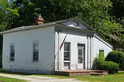 Connecticut Land Company Office | |
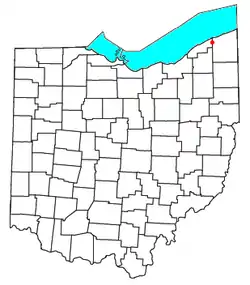 Location of Unionville, Ohio | |
| Coordinates: 41°46′49″N 81°00′10″W / 41.78028°N 81.00278°W | |
| Country | United States |
| State | Ohio |
| Counties | Ashtabula, Lake |
| Elevation | 741 ft (226 m) |
| Time zone | UTC-5 (Eastern (EST)) |
| • Summer (DST) | UTC-4 (EDT) |
| ZIP code | 44088 |
| Area code | 440 |
| GNIS feature ID | 1065411[1] |
Unionville is an unincorporated community on the line between northwestern Harpersfield Township in Ashtabula County and eastern Madison Township in Lake County in the U.S. state of Ohio.[1] It has a post office with the ZIP code 44088.[2] It lies along State Route 84.
The community's location where two counties meet caused the name "Union" to be selected.[3] Unionville is the site of the land office of the Connecticut Western Reserve; it is listed on the National Register of Historic Places.[4]
Notable person
- Edwin Wheeler, Wisconsin jurist and legislator
References
- 1 2 "Unionville, Ohio". Geographic Names Information System. United States Geological Survey, United States Department of the Interior.
- ↑ USPS – Cities by ZIP Code Archived October 10, 2007, at the Wayback Machine
- ↑ Overman, William Daniel (1958). Ohio Town Names. Akron, OH: Atlantic Press. p. 136.
- ↑ Brcak, Nancy J (Summer–Autumn 1989). "Country Carpenters, Federal Buildings: An Early Architectural Tradition in Ohio's Western Reserve". Ohio History. Ohio Historical Society. 98: 135. Retrieved November 23, 2014.
Municipalities and communities of Ashtabula County, Ohio, United States | ||
|---|---|---|
| Cities |  Map of Ohio highlighting Ashtabula County | |
| Villages | ||
| Townships | ||
| CDPs | ||
| Unincorporated communities | ||
| Footnotes | ‡This populated place also has portions in an adjacent county or counties | |
Municipalities and communities of Lake County, Ohio, United States | ||
|---|---|---|
| Cities |  Map of Ohio highlighting Lake County | |
| Villages | ||
| Townships | ||
| CDP | ||
| Unincorporated communities | ||
This article is issued from Wikipedia. The text is licensed under Creative Commons - Attribution - Sharealike. Additional terms may apply for the media files.