Usia | |
|---|---|
Village | |
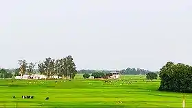
 Farms in Usia | |
 Usia Location of Usia in Uttar Pradesh | |
| Coordinates: 25°25′51″N 83°42′27″E / 25.4309°N 83.7075°E | |
| Country | India |
| State | Uttar Pradesh |
| District | Ghazipur |
| Established | 1570 |
| Founded by | zamindarJahangirr Khan and zamindar barbal khan |
| Government | |
| • Type | Gram Pradhan |
| • Body | Gram Panchayat |
| Area | |
| • Total | 2,077 ha (5,132 acres) |
| • Land | 2,037.534 ha (5,034.856 acres) |
| • Water | 39.466 ha (97.523 acres) |
| Population (2011) | |
| • Total | 23,913[1] |
| Demonym | Kamsaari |
| Languages | |
| • official language | Hindi, Bhojpuri |
| Time zone | UTC+5:30 (IST) |
| ISO 3166 code | IN-UP |
| Vehicle registration | UP 61 |
Usia is a village in Kamsaar, Uttar Pradesh, India. It lies southeast of Ghazipur and east of Dildarnagar, close to the Bihar State border. Most of the inhabitants live in an area of 378 acres. The village is home to 25,000 people, made up of 13,000 men and 12,000 women. The population increased by 21.4% from 1991 - 2001.[2] Scheduled castes comprise 83% of the population. The literacy rate is 83% among men and 63% among women. The land spread of Usia is almost 26 km² in Ghazipur District. Almost 8500 Kamsaar Pathans lived in the village as of 2011 Census.[2]
Nazir Hussain was from Usia.

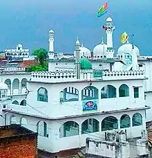
Biggest Masjid kf Usia built in 1580 and was renovated in 1960Side view
Historical population
| Year | Pop. | ±% |
|---|---|---|
| 1861 | 5,650 | — |
| 1871 | 5,555 | −1.7% |
| 1881 | 5,300 | −4.6% |
| 1891 | 5,700 | +7.5% |
| 1901 | 5,720 | +0.4% |
| 1911 | 6,612 | +15.6% |
| 1921 | 7,275 | +10.0% |
| 1931 | 8,050 | +10.7% |
| 1941 | 8,855 | +10.0% |
| 1951 | 9,228 | +4.2% |
| 1961 | 10,715 | +16.1% |
| 1971 | 11,787 | +10.0% |
| 1981 | 12,965 | +10.0% |
| 1991 | 15,038 | +16.0% |
| 2001 | 18,562 | +23.4% |
| 2011 | 23,913 | +28.8% |
| Source:Census of India[3][4][5] | ||
References
- ↑ "2011 census of India".
- 1 2 "Bhulekh".
- ↑ "Census of India". mospi.gov.in. Archived from the original on 13 August 2008. Retrieved 23 June 2008.
- ↑ "2011 census of India".
- ↑ "Historical Census of India". Archived from the original on 17 February 2013. Retrieved 5 November 2015.
External links
- Google (18 April 2013). "Usia, Uttar Pradesh, India" (Map). Google Maps. Google. Retrieved 18 April 2013.
This article is issued from Wikipedia. The text is licensed under Creative Commons - Attribution - Sharealike. Additional terms may apply for the media files.