 | |
| Length | 1.3 km (0.81 mi) |
|---|---|
| Location | Warsaw |
| East end | Rosoła Street |
| West end | Stryjeńskich Street |
| Construction | |
| Inauguration | 1980s |
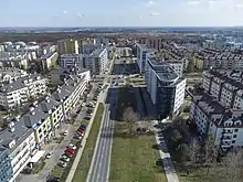
The Wąwozowa Street (Polish: Ulica Wąwozowa) is one of the principal streets of the Warsaw's residential neighborhood of Kabaty in the Ursynów district. It runs along the East-West axis, linking the Rosoła Street with the Stryjeńskich Street. The name comes from gorges (Polish: wąwozy) bordering escarpment of the Vistula,[1] and was given in 1978 by the National Council of the Capital City of Warsaw resolution.[2]
The street was charted in 1980s during the development of Kabaty. Since 1995, the Kabaty metro station has been located beneath the street.[3] There are two traffic lights – first one on the junction with the Komisji Edukacji Narodowej Avenue,[4] and the second one with the Jerzy Zaruba Street (Polish: Ulica Jerzego Zaruby).[5]
There is a cycle path along the road.[6]
References
- ↑ "Wąwozowa. Pochodzenie nazwy". Warsaw (in Polish).
- ↑ "Uchwała nr 32 Rady Narodowej m.st. Warszawy z dnia 5 grudnia 1977 r." [Resolution No. 32 of the National Council of the Capital City of Warsaw of December 5, 1977.]. Official Journal of the Capital City of Warsaw (in Polish).
- ↑ "I linia metra". SISKOM – Stowarzyszenie Integracji Stołecznej Komunikacji (in Polish).
- ↑ "Al. Komisji Edukacji Narodowej". SISKOM – Stowarzyszenie Integracji Stołecznej Komunikacji (in Polish).
- ↑ "Dobra wiadomość: będą światła na skrzyżowaniu Wąwozowa/Zaruby". Ursynów (in Polish).
- ↑ "Idą wielkie zmiany na Wąwozowej. Dla pieszych i rowerzystów". Halo Ursynów (in Polish).