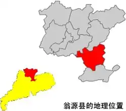
Wengyuan
翁源县 Yungyun | |
|---|---|
 | |
 Location in Shaoguan and Guangdong | |
| Coordinates: 24°21′01″N 114°07′49″E / 24.3503°N 114.1303°E | |
| Country | People's Republic of China |
| Province | Guangdong |
| Prefecture-level city | Shaoguan |
| Area | |
| • County | 2,234 km2 (863 sq mi) |
| Highest elevation [1] (Qixingdun peak (七星墩)) | 1,300 m (4,300 ft) |
| Lowest elevation [1] (Guangdu town) | 100 m (300 ft) |
| Population (2019) | 421,756 |
| • Urban | 123,685 |
| • Rural | 298,071 |
| Time zone | UTC+8 (China Standard) |
Wengyuan (postal: Yungyun; Chinese: 翁源; pinyin: Wēngyuán) is a county in the north of Guangdong Province, China, bordering Jiangxi to the northeast. It is under the administration of Shaoguan City. It has a population of 421,756 in 2019, 99.55% of whom speak Hakka. Yao languages are spoken in some parts of the county. 0.616% of the population belongs to minority ethnic groups, most of them Yao.[2]
The name means 'source of the Weng River', which is a tributary of the Bei River.
Wengyuan is noted for its plum blossoms[3] and orchid floriculture, which account for 70% of China's orchid production.[4][5]
Administrative divisions
The county is responsible for the administration of eight towns:[6]
- Towns
- Tielong (铁龙镇), formerly known as Tielong Forest Farm (铁龙林场)
Climate
| Climate data for Wengyuan (2011–2020 normals, extremes 1981–2010) | |||||||||||||
|---|---|---|---|---|---|---|---|---|---|---|---|---|---|
| Month | Jan | Feb | Mar | Apr | May | Jun | Jul | Aug | Sep | Oct | Nov | Dec | Year |
| Record high °C (°F) | 28.3 (82.9) |
30.7 (87.3) |
33.1 (91.6) |
34.1 (93.4) |
36.1 (97.0) |
38.3 (100.9) |
39.5 (103.1) |
38.5 (101.3) |
38.1 (100.6) |
36.7 (98.1) |
34.5 (94.1) |
29.0 (84.2) |
39.5 (103.1) |
| Mean daily maximum °C (°F) | 16.6 (61.9) |
18.8 (65.8) |
21.3 (70.3) |
26.0 (78.8) |
29.6 (85.3) |
32.2 (90.0) |
33.8 (92.8) |
33.6 (92.5) |
31.8 (89.2) |
28.1 (82.6) |
23.9 (75.0) |
17.9 (64.2) |
26.1 (79.0) |
| Daily mean °C (°F) | 11.4 (52.5) |
13.5 (56.3) |
16.6 (61.9) |
21.2 (70.2) |
24.8 (76.6) |
27.2 (81.0) |
28.2 (82.8) |
27.8 (82.0) |
26.3 (79.3) |
22.5 (72.5) |
18.4 (65.1) |
12.5 (54.5) |
20.9 (69.6) |
| Mean daily minimum °C (°F) | 8.0 (46.4) |
10.0 (50.0) |
13.5 (56.3) |
17.7 (63.9) |
21.8 (71.2) |
24.1 (75.4) |
24.6 (76.3) |
24.3 (75.7) |
22.7 (72.9) |
18.6 (65.5) |
14.8 (58.6) |
9.0 (48.2) |
17.4 (63.4) |
| Record low °C (°F) | −2.1 (28.2) |
−0.6 (30.9) |
−0.8 (30.6) |
6.8 (44.2) |
11.5 (52.7) |
15.6 (60.1) |
19.8 (67.6) |
21.1 (70.0) |
14.3 (57.7) |
6.6 (43.9) |
1.2 (34.2) |
−2.3 (27.9) |
−2.3 (27.9) |
| Average precipitation mm (inches) | 67.0 (2.64) |
81.9 (3.22) |
163.9 (6.45) |
227.3 (8.95) |
273.4 (10.76) |
323.4 (12.73) |
171.0 (6.73) |
181.0 (7.13) |
126.1 (4.96) |
38.8 (1.53) |
47.2 (1.86) |
47.1 (1.85) |
1,748.1 (68.81) |
| Average precipitation days (≥ 0.1 mm) | 9.3 | 11.0 | 17.4 | 17.2 | 18.7 | 19.0 | 16.0 | 16.2 | 11.5 | 5.3 | 6.8 | 6.9 | 155.3 |
| Average snowy days | 0.3 | 0.1 | 0 | 0 | 0 | 0 | 0 | 0 | 0 | 0 | 0 | 0.1 | 0.5 |
| Average relative humidity (%) | 72 | 76 | 80 | 81 | 81 | 83 | 79 | 80 | 77 | 70 | 71 | 69 | 77 |
| Mean monthly sunshine hours | 100.6 | 81.2 | 67.5 | 83.4 | 116.3 | 134.3 | 198.0 | 185.4 | 171.2 | 173.7 | 147.4 | 137.3 | 1,596.3 |
| Percent possible sunshine | 30 | 25 | 18 | 22 | 28 | 33 | 48 | 47 | 47 | 49 | 45 | 42 | 36 |
| Source: China Meteorological Administration[7][8] | |||||||||||||
References
- 1 2 "自然地理-翁源县人民政府".
- ↑ "民族人口-翁源县人民政府". www.wengyuan.gov.cn. Retrieved 2021-02-12.
- ↑ "广东春日去寻芳 翁源县赏花之旅". travel.sina.com.cn. Retrieved 2021-02-12.
- ↑ 钟宏连 (2021-01-25). "韶关兰花来莞展销". finance.sina.com.cn. Retrieved 2021-02-12.
- ↑ "以花为"径" "中国兰花第一县"广东翁源的脱贫路-中新网". www.chinanews.com. Retrieved 2021-02-12.
- ↑ "2020年统计用区划代码". www.stats.gov.cn. Retrieved 2021-02-14.
- ↑ 中国气象数据网 – WeatherBk Data (in Simplified Chinese). China Meteorological Administration. Retrieved 28 May 2023.
- ↑ 中国气象数据网 (in Simplified Chinese). China Meteorological Administration. Retrieved 28 May 2023.
This article is issued from Wikipedia. The text is licensed under Creative Commons - Attribution - Sharealike. Additional terms may apply for the media files.