West Karawang
Karawang Barat Karawang Kulon | |
|---|---|
| Regional transcription(s) | |
| • Sundanese | ᮊᮛᮝᮀ ᮊᮥᮜᮧᮔ᮪ |
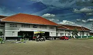
 Karawang Station | |
| Coordinates: 6°17′53″S 107°17′56″E / 6.29806°S 107.29889°E | |
| Country | |
| Province | West Java |
| Regency | Karawang Regency |
| Government | |
| • Camat | Lasmi Ningrum |
| • Secretary | Khaerul Bahri |
| Area | |
| • Total | 33.68 km2 (13.00 sq mi) |
| Elevation | 22 m (72 ft) |
| Population (2020 Census)[1] | |
| • Total | 161,554 |
| • Density | 4,800/km2 (12,000/sq mi) |
| Time zone | UTC+7 (IWT) |
| Postal code | 4131x |
| Area code | (+62) 264 |
| Villages | 8 |
| Website | Official website |
West Karawang (Indonesian: Karawang Barat, Sundanese: ᮊᮛᮝᮀ ᮊᮥᮜᮧᮔ᮪; Karawang Kulon) is a district of Karawang Regency which serves as its administrative center. The district was established in 2003 as a result of Karawang Regency's new regulation regarding its administrative divisions.[2] It is divided into 8 villages which are as follows:[1]
- Karangpawitan
- Mekarjati
- Nagasari
- Tanjungmekar (location of district HQ)
- Tanjungpura
- Tunggakjati
- West Adiarsa
- West Karawang
Climate
Karawang has a tropical monsoon climate (Am) with moderate to little rainfall from May to October and heavy rainfall from November to April.
| Climate data for Karawang | |||||||||||||
|---|---|---|---|---|---|---|---|---|---|---|---|---|---|
| Month | Jan | Feb | Mar | Apr | May | Jun | Jul | Aug | Sep | Oct | Nov | Dec | Year |
| Mean daily maximum °C (°F) | 30.1 (86.2) |
30.2 (86.4) |
30.9 (87.6) |
31.7 (89.1) |
32.0 (89.6) |
32.1 (89.8) |
32.1 (89.8) |
32.7 (90.9) |
33.2 (91.8) |
33.2 (91.8) |
32.2 (90.0) |
31.2 (88.2) |
31.8 (89.3) |
| Daily mean °C (°F) | 26.4 (79.5) |
26.4 (79.5) |
26.8 (80.2) |
27.2 (81.0) |
27.3 (81.1) |
27.1 (80.8) |
26.8 (80.2) |
27.2 (81.0) |
27.6 (81.7) |
27.8 (82.0) |
27.4 (81.3) |
27.0 (80.6) |
27.1 (80.7) |
| Mean daily minimum °C (°F) | 22.7 (72.9) |
22.7 (72.9) |
22.7 (72.9) |
22.8 (73.0) |
22.7 (72.9) |
22.1 (71.8) |
21.6 (70.9) |
21.7 (71.1) |
22.0 (71.6) |
22.4 (72.3) |
22.7 (72.9) |
22.8 (73.0) |
22.4 (72.4) |
| Average rainfall mm (inches) | 279 (11.0) |
260 (10.2) |
214 (8.4) |
149 (5.9) |
124 (4.9) |
99 (3.9) |
65 (2.6) |
38 (1.5) |
59 (2.3) |
122 (4.8) |
203 (8.0) |
211 (8.3) |
1,823 (71.8) |
| Source: Climate-Data.org[3] | |||||||||||||
See also
- San Diego Hills, a cemetery in West Karawang
References
- 1 2 3 4 "Karawang Barat Subdistrict in Figures 2020". Statistics Indonesia. Retrieved December 16, 2020.
- ↑ "GAMBARAN UMUM WILAYAH KABUPATEN KARAWANG DAN GAMBARAN WILAYAH KECAMATAN TELUK JAMBE TIMUR" (PDF). UNPAS Repository. Retrieved 2018-11-03.
- ↑ "Climate: Karawang". Climate-Data.org. Retrieved 12 November 2020.
This article is issued from Wikipedia. The text is licensed under Creative Commons - Attribution - Sharealike. Additional terms may apply for the media files.

