Wiang Pa Pao
เวียงป่าเป้า | |
|---|---|
 | |
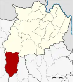 District location in Chiang Rai province | |
| Coordinates: 19°20′54″N 99°30′24″E / 19.34833°N 99.50667°E | |
| Country | Thailand |
| Province | Chiang Rai |
| Seat | Wiang |
| Area | |
| • Total | 1,217.0 km2 (469.9 sq mi) |
| Population (2008) | |
| • Total | 68,198 |
| • Density | 56.2/km2 (146/sq mi) |
| Time zone | UTC+7 (ICT) |
| Postal code | 57170 |
| Geocode | 5711 |
Wiang Pa Pao (Thai: เวียงป่าเป้า; IPA: [wīaŋ pàː pâw]) is the southwesternmost district (amphoe) of Chiang Rai province, northern Thailand.
Geography
Neighboring districts are (from the north clockwise): Mae Suai and Phan of Chiang Rai Province; Wang Nuea and Mueang Pan of Lampang province; Doi Saket and Phrao of Chiang Mai province.
The Khun Tan Range runs along the west side of the district and its highest point, 2,031 m high Doi Mae Tho, is at its southwest end.
History
Wiang Pa Pao was one of the mueang in northern Thailand. In 1905 the District Wiang Pa Pao was merged with Mueang Phong and renamed Mae Suai,[1] while the central area of the old mueang kept the name as the minor district (King Khwaeng) Wiang Pa Pao. In 1907 it was upgraded to a full district.[2]
Administration
The district is divided into seven sub-districts (tambons), which are further subdivided into 92 villages (mubans). There are two sub-district municipalities (thesaban tambons). Wiang Pa Pao covers parts of tambon Wiang, and Mae Khachan covers parts of tambon Mae Chai. There are a further seven tambon administrative organizations (TAO).
| No. | Name | Thai | Villages | Pop.[3] |
|---|---|---|---|---|
| 1. | San Sali | สันสลี | 13 | 9,051 |
| 2. | Wiang | เวียง | 12 | 15,521 |
| 3. | Ban Pong | บ้านโป่ง | 7 | 5,193 |
| 4. | Pa Ngio | ป่างิ้ว | 16 | 9,375 |
| 5. | Wiang Kalong | เวียงกาหลง | 15 | 9,572 |
| 6. | Mae Chedi | แม่เจดีย์ | 16 | 9,742 |
| 7. | Mae Chedi Mai | แม่เจดีย์ใหม่ | 14 | 9,744 |
References
- ↑ แจ้งความกระทรวงมหาดไทย [เปลี่ยนชื่อแขวงแม่กก เรียกแขวงเมืองเชียงราย กับรวมแขวงเมืองพง แขวงเมืองเวียงป่าเป้าเรียกแขวงแม่ซวย] (PDF). Royal Gazette (in Thai). 22 (39): 950. 24 December 1905. Archived from the original (PDF) on 27 January 2012.
- ↑ แจ้งความกระทรวงมหาดไทย เรื่อง ยกกิ่งแขวงเวียงเป้าขึ้นเป็นแขวงเวียงป่าเป้า อยู่ในความบังคับบัญชาของบริเวณพายัพเหนือ (PDF). Royal Gazette (in Thai). 24 (7): 161. 19 May 1907. Archived from the original (PDF) on 27 January 2012.
- ↑ "Population statistics 2008". Department of Provincial Administration.
External links
 Chiang Rai Province travel guide from Wikivoyage
- amphoe.com (Thai)