William Cullen Bryant Viaduct (Roslyn Viaduct) | |
|---|---|
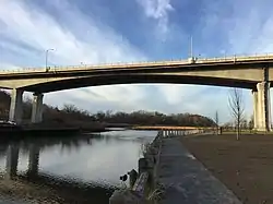
 The new span of the Bryant Viaduct over Hempstead Harbor, as seen in 2015. | |
| Coordinates | 40°48′14″N 73°39′04″W / 40.8038°N 73.651°W |
| Carries | |
| Crosses | Hempstead Harbor |
| Locale | Flower Hill and Roslyn, New York, United States |
| Named for | William Cullen Bryant[1] |
| Owner | NYSDOT |
| Maintained by | NYSDOT |
| Characteristics | |
| Design | Precast concrete segmental bridge |
| Total length | 0.50 mi (0.80 km)[2] |
| No. of lanes | 4 (2 in each direction) |
| Design life | 75 years[3] |
| History | |
| Construction end | |
| Construction cost | $127 Million (2005 USD) |
| Statistics | |
| Daily traffic | Approx. 38,000 vehicles daily (2005)[4] |
| Location | |
The William Cullen Bryant Viaduct, historically known as the Roslyn Viaduct, is a viaduct that carries four lanes of Northern Boulevard (NY 25A) over Hempstead Harbor between the Incorporated Villages of Flower Hill and Roslyn, in Nassau County, on Long Island, in New York, United States. It serves as a bypass of Roslyn's downtown. The original bridge opened in 1949 and was replaced in phases between 2005 and 2012.
History
Original bridge (1949–2012)
The original bridge was completed in 1949, and opened on October 21 of that year by Governor Thomas E. Dewey.[5][2] The four-lane bridge was built using a pin-hanger design.[2] The construction and subsequent opening of the bridge eliminated the traffic bottleneck on Main Street and Old Northern Boulevard in the heart of Roslyn that had resulted from the increasing number of automobiles on the roads.[2]

By the 1990s, the bridge was beginning to show its age. Advancements in bridge engineering and safety rendered the structure obsolete; New York stopped building bridges using the pin-hanger design in 1968.[2] Additionally, there were concerns regarding the bridge's structural integrity – especially after the 1983 Mianus River Bridge Disaster, in which a similarly designed bridge carrying Interstate 95 in Connecticut collapsed.[2] After careful consideration, officials ultimately decided to replace the bridge, with initial development for the project first taking place between 1992 and 1993.[4]
Current bridge (2012–present)
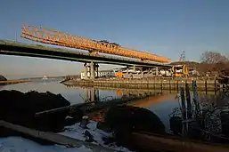
In 2005, construction commenced on a replacement bridge, as the original one was in a state of disrepair, was structurally-obsolete, lacked shoulders, and exceeded its intended use life.[6][2][4] Given the lack of efficient detour routes, construction was carried out in phases; one side would remain open whilst the other was demolished and rebuilt. Three lanes would be in use at any given time, and their directions would be reversible; in the mornings, there would be two westbound lanes and one eastbound lane, and the afternoons/evenings would see two eastbound lanes and one westbound lane.[6][7][8] Construction was originally intended to be completed by 2007 - but numerous factors led to multiple delays, and the replacement bridge was finally completed in 2012.[4] The new bridge features many enhancements, including a shoulder lane, an improved walkway, and better drainage.[2] The new bridge is a total of 13 feet (4 Meters) wider than its predecessor.[2]
The new bridge was built using precast concrete segments, and was the first bridge in the area to be built using this design method.[6][7][9]
Dedication and re-naming, 2012
In 2012, the bridge was officially dedicated to and renamed after the late poet, journalist, and Roslyn resident, William Cullen Bryant, by then-NY State Senator Jack Martins, through a bill in the New York State Senate.[1] Bryant, who had purchased a home in Roslyn in 1843, was one of the most famous and influential residents in Roslyn's history.[1]
See also
References
- 1 2 3 "Bill Introduced By Senator Martins to Rename Roslyn Viaduct Passes Senate". NY State Senate. 2012-03-27. Retrieved 2020-08-09.
- 1 2 3 4 5 6 7 8 9 10 Beller, Peter C. (2005-11-13). "Roslyn Is Getting A New Viaduct". The New York Times. ISSN 0362-4331. Retrieved 2020-08-09.
- ↑ "Roslyn Viaduct" (PDF). Aspirebridge.com.
- 1 2 3 4 5 Endo, Emi (2011-12-04). "Roslyn viaduct construction nearly done". Newsday. Retrieved 2020-08-09.
- ↑ Russell, Ellen; Russell, Sargent (2009). Roslyn. Images of America. Arcadia Publishing. p. 56. ISBN 978-0-7385-6505-7. LCCN 2008942609.
- 1 2 3 "Roslyn Viaduct" (PDF). Aspirebridge.com.
- 1 2 Endo, Emi (1991-11-14). "From the archives: Roslyn viaduct's long haul". Newsday. Retrieved 2020-08-09.
- ↑ Campbell, Kelly (2009-12-30). "New Year's Lane Closures for Roslyn Viaduct". Port Washington, NY Patch. Retrieved 2020-11-24.
- ↑ "New York OPD Geographic Information Gateway". opdgig.dos.ny.gov. Retrieved 2021-07-28.