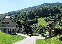
Zgornja Dobrava | |
|---|---|
 | |
 Zgornja Dobrava Location in Slovenia | |
| Coordinates: 46°8′11.89″N 14°46′33.93″E / 46.1366361°N 14.7760917°E | |
| Country | |
| Traditional region | Upper Carniola |
| Statistical region | Central Slovenia |
| Municipality | Moravče |
| Area | |
| • Total | 0.39 km2 (0.15 sq mi) |
| Elevation | 405 m (1,329 ft) |
| Population (2002) | |
| • Total | 48 |
| [1] | |
Zgornja Dobrava (pronounced [ˈzɡoːɾnja dɔˈbɾaːʋa]; German: Oberdobrawa[2]) is a small settlement east of Moravče in central Slovenia. The area is part of the traditional region of Upper Carniola. It is now included with the rest of the municipality in the Central Slovenia Statistical Region.[3]
Name
Zgornja Dobrava was attested in historical sources as Dobraw in 1386 and 1429.[4]
History
Until 1953, when it was administratively separated and made a village in its own right, the neighboring village of Ples was a hamlet of Zgornja Dobrava.[5][6]
References
- ↑ Statistical Office of the Republic of Slovenia Archived November 18, 2008, at the Wayback Machine
- ↑ Leksikon občin kraljestev in dežel zastopanih v državnem zboru, vol. 6: Kranjsko. 1906. Vienna: C. Kr. Dvorna in Državna Tiskarna, p. 21.
- ↑ Moravče municipal site
- ↑ "Zgornja Dobrava". Slovenska historična topografija. ZRC SAZU Zgodovinski inštitut Milka Kosa. Retrieved November 1, 2020.
- ↑ Topole, Maja (2003). Geografija občine Moravče. Ljubljana: Založba ZRC. p. 194.
- ↑ Razširjeni seznam sprememb naselij: od 1948 do 1964: (poimenovanja, združevanja, odcepitve, pristavki, razglastive in ukinitve). Ljubljana: Zavod SR Slovenije za statistiko. 1965. p. 72.
External links
 Media related to Zgornja Dobrava at Wikimedia Commons
- Zgornja Dobrava on Geopedia
This article is issued from Wikipedia. The text is licensed under Creative Commons - Attribution - Sharealike. Additional terms may apply for the media files.
