| Zheltau | |
|---|---|
| Желтау | |
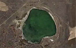
 Sentinel-2 image of the lake | |
 Zheltau | |
| Location | Kazakh Uplands |
| Coordinates | 53°01′36″N 69°31′31″E / 53.02667°N 69.52528°E |
| Type | Salt lake |
| Basin countries | Kazakhstan |
| Max. length | 2.5 kilometers (1.6 mi) |
| Max. width | 2.4 kilometers (1.5 mi) |
| Surface area | 4.99 square kilometers (1.93 sq mi) |
| Max. depth | 3 meters (9.8 ft) |
| Residence time | UTC+6 |
| Shore length1 | 8.1 kilometers (5.0 mi) |
| Surface elevation | 340 meters (1,120 ft) |
| Islands | none |
| Settlements | Zheltau |
| 1 Shore length is not a well-defined measure. | |
Zheltau (Kazakh: Желтау) is a salt lake in Zerendi District, Akmola Region, Kazakhstan.[1]
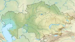
The lake lies 28 kilometers (17 mi) To the SSE of the town of Kokshetau.[2]
Geography
Zheltau lies in a tectonic depression of the Kazakh Uplands nearly 50 kilometers (31 mi) to the east of the Kokshetau Hills and 26 kilometers (16 mi) to the ENE of lake Zerendi. Zheltau village, former Oktyabr, is located to the north, close to the northern lakeshore.[2][1]
See also
References
- 1 2 "N-42 Topographic Chart (in Russian)". Retrieved 24 December 2023.
- 1 2 Google Earth
External links
This article is issued from Wikipedia. The text is licensed under Creative Commons - Attribution - Sharealike. Additional terms may apply for the media files.