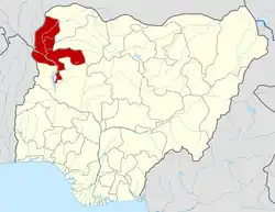
Zuru
Azuguru | |
|---|---|
LGA and town | |
 Zuru Location in Nigeria | |
| Coordinates: 11°26′06″N 5°14′06″E / 11.435°N 5.235°E | |
| Country | |
| State | Kebbi |
| Government | |
| • Gomo | Maj. Gen. Mohammed Sani Sami (rtd) |
| Time zone | UTC+1 (WAT) |
Zuru is a Local Government Area in Kebbi State, Nigeria. Its headquarters is in the town of Zuru. It is also the Headquarters of Zuru Emirate. The Emirate comprises four local government areas, namely: Wasagu/Danko, Fakai, Sakaba and Zuru.
It has an area of 653 km2 (252 sq mi) and a population of 165,547 at the 2006 census.[1]
The postal code of the area is 872.[2]
Climatic Condition
The climate is hot and oppressive, with a year-round temperature range of 58°F to 100°F, with occasional dips below or above 105°F.[3][4][5]
Temperature
With warming stripes signifying the average annual temperature, climate change is significantly raising the temperature in Zuru.[6]
Topography
In the context of this report, Zuru is located at geographical coordinates of 11.435 degrees latitude, 5.235 degrees longitude, and an elevation of 1,293 feet.
The landscape within a 2-mile radius of Zuru exhibits relatively minor changes in elevation, with the most significant elevation difference measuring 413 feet, and an average elevation above sea level of about 1,328 feet. Expanding the radius to 10 miles continues to show only modest elevation variations, totaling 768 feet. However, when considering a 50-mile radius, the terrain displays notable fluctuations in elevation, amounting to 1,683 feet.
The region within a 2-mile radius of Zuru is characterized by cropland (66%), trees (14%), and grassland (13%). Extending the scope to a 10-mile radius reveals a landscape primarily consisting of cropland (77%) and shrubs (10%). When looking at a 50-mile radius, cropland covers 68% of the area, with grassland making up 12% of the land cover.[7]
Districts
Bedi
Zodi
Tadurga
Seme
Senchi
Ciroman
Dabai
Isgogo
Dago Manga
Ushe
Rafin Zuru
Rikoto
Rumu
Doben[8]
References
- ↑ HASC, population, area and Headquarters Statoids
- ↑ "Post Offices- with map of LGA". NIPOST. Archived from the original on October 7, 2009. Retrieved 2009-10-20.
- ↑ "Zuru Climate, Weather By Month, Average Temperature (Nigeria) - Weather Spark". weatherspark.com. Retrieved 2023-09-10.
- ↑ "Zuru, Kebbi, NG Climate Zone, Monthly Averages, Historical Weather Data". tcktcktck.org. Retrieved 2023-09-10.
- ↑ "Zuru, Kebbi, Nigeria - City, Town and Village of the world". en.db-city.com. Retrieved 2023-09-10.
- ↑ "Climate Change Zuru". meteoblue. Retrieved 2023-11-18.
- ↑ "Zuru Climate, Weather By Month, Average Temperature (Nigeria) - Weather Spark". weatherspark.com. Retrieved 2023-10-29.
- ↑ "Zuru Local Government Area". www.finelib.com. Retrieved 2023-10-29.
