Anchieta | |
|---|---|
| Municipality of Anchieta | |
.jpg.webp) | |
 Coat of arms | |
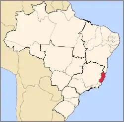
 Anchieta Location in Brazil | |
| Coordinates: 20°48′20″S 40°38′40″W / 20.80556°S 40.64444°W | |
| Country | Brazil |
| Region | Southeast |
| State | Espírito Santo |
| Area | |
| • Total | 412 km2 (159 sq mi) |
| Population (2020)[1] | |
| • Total | 29,779 |
| • Density | 72/km2 (190/sq mi) |
| Time zone | UTC−3 (BRT) |
Anchieta is a municipality in the Brazilian state of Espírito Santo. Its population was 29,779 in 2020 and its area is 412 km2 (159 sq mi).[2] Its average elevation is 2 m (6.6 ft) above sea level.
Formerly known as Reritiba, the city was renamed after the Jesuit Spanish missionary and saint José de Anchieta (1534-1597).
See also
References
Wikivoyage has a travel guide for Anchieta (Espírito Santo).
Capital: Vitória | ||||||||||
| Mesoregion Central |
|  | ||||||||
| Mesoregion Litoral Norte |
| |||||||||
| Mesoregion Noroeste |
| |||||||||
| Mesoregion Sul |
| |||||||||
This article is issued from Wikipedia. The text is licensed under Creative Commons - Attribution - Sharealike. Additional terms may apply for the media files.