Ibatiba | |
|---|---|
 | |
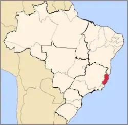
 Location in Espírito Santo state | |
 Ibatiba Location in Brazil | |
| Coordinates: 20°14′11″S 41°30′33″W / 20.23639°S 41.50917°W | |
| Country | Brazil |
| Region | Southeast |
| State | Espírito Santo |
| Established | 7 November 1981 |
| Area | |
| • Total | 241 km2 (93 sq mi) |
| Population (2020 [1]) | |
| • Total | 26,426 |
| • Density | 110/km2 (280/sq mi) |
| Time zone | UTC−3 (BRT) |
Ibatiba, Espírito Santo is a municipality located in the Brazilian state of Espírito Santo. Its population was 26,426 (2020) and its area is 241 km²[2]
References
- ↑ IBGE 2020
- ↑ "Municipality data". Brazilian Institute of Geography and Statistics (IBGE). Retrieved 2016-06-15.
Capital: Vitória | ||||||||||
| Mesoregion Central |
|  | ||||||||
| Mesoregion Litoral Norte |
| |||||||||
| Mesoregion Noroeste |
| |||||||||
| Mesoregion Sul |
| |||||||||
This article is issued from Wikipedia. The text is licensed under Creative Commons - Attribution - Sharealike. Additional terms may apply for the media files.