Antanamitarana | |
|---|---|
 | |
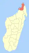
 Antanamitarana Location in Madagascar | |
| Coordinates: 12°23′S 49°18′E / 12.383°S 49.300°E | |
| Country | |
| Region | Diana |
| District | Antsiranana II |
| Government | |
| • Mayor | Anondaza Amina |
| Area | |
| • Land | 76 km2 (29 sq mi) |
| Elevation | 120 m (390 ft) |
| Population (2016)[2] | |
| • Total | 6,227 |
| Time zone | UTC3 (EAT) |
| Postal code | 202 |
Antanamitarana is a rural municipality in Madagascar. It belongs to the district of Antsiranana II, which is a part of Diana Region. The population of the municipality was estimated to be approximately 6227 in 2016.
It is situated at 8 km South of Diego Suarez, on the National Road 6. The airport of Diego Suarez is in this municipality. 5 villages belong to this municipality: Maromagniry, Antafiamalama, Antanamitarana, Ambodimagnary and Ambodimanga.
 sunset
 Western part of Fokontany Maromagniry
 Catholic school of Maromagniry
 School of EPP Ambodimanga, Antanamitarana
 School of EPP Ambodimanga, Antanamitarana
References
| Ambanja (24) - 203 |
|  |
|---|---|---|
| Ambilobe (15) - 204 | ||
| Antsiranana (Diego Suarez) (1) - 201 | ||
| Antsiranana II (22) - 202 |
| |
| Nosy Be (5) - 207 |
| |
5 districts; 51 communes | ||
Wikimedia Commons has media related to Antanamitarana.
This article is issued from Wikipedia. The text is licensed under Creative Commons - Attribution - Sharealike. Additional terms may apply for the media files.