Bad Schönau | |
|---|---|
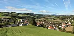 Bad Schönau seen from the east | |
 Coat of arms | |
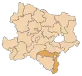
 Bad Schönau Location within Austria | |
| Coordinates: 47°29′00″N 16°14′00″E / 47.48333°N 16.23333°E | |
| Country | Austria |
| State | Lower Austria |
| District | Wiener Neustadt-Land |
| Government | |
| • Mayor | Ferdinand Schwarz (ÖVP) |
| Area | |
| • Total | 13.59 km2 (5.25 sq mi) |
| Elevation | 490 m (1,610 ft) |
| Population (2018-01-01)[2] | |
| • Total | 721 |
| • Density | 53/km2 (140/sq mi) |
| Time zone | UTC+1 (CET) |
| • Summer (DST) | UTC+2 (CEST) |
| Postal code | 2853 |
| Area code | 02646 |
| Vehicle registration | WB |
| Website | www.bad-schoenau.gv.at |
Bad Schönau (German: [baːt ˈʃøːnaʊ̯] ⓘ) is a municipality in the district of Wiener Neustadt-Land in the Austrian state of Lower Austria.
Population
| Year | Pop. | ±% |
|---|---|---|
| 1869 | 653 | — |
| 1880 | 669 | +2.5% |
| 1890 | 589 | −12.0% |
| 1900 | 563 | −4.4% |
| 1910 | 609 | +8.2% |
| 1923 | 605 | −0.7% |
| 1934 | 576 | −4.8% |
| 1939 | 564 | −2.1% |
| 1951 | 594 | +5.3% |
| 1961 | 614 | +3.4% |
| 1971 | 659 | +7.3% |
| 1981 | 729 | +10.6% |
| 1991 | 711 | −2.5% |
| 2001 | 725 | +2.0% |
| 2011 | 776 | +7.0% |
References
- ↑ "Dauersiedlungsraum der Gemeinden Politischen Bezirke und Bundesländer - Gebietsstand 1.1.2018". Statistics Austria. Retrieved 10 March 2019.
- ↑ "Einwohnerzahl 1.1.2018 nach Gemeinden mit Status, Gebietsstand 1.1.2018". Statistics Austria. Retrieved 9 March 2019.

Parish church Saints Peter and Paul
This article is issued from Wikipedia. The text is licensed under Creative Commons - Attribution - Sharealike. Additional terms may apply for the media files.