Chipao
Chipaw | |
|---|---|
 | |
| Country | |
| Region | Ayacucho |
| Province | Lucanas |
| Capital | Chipao |
| Government | |
| • Mayor | William Sandro Espino Ferrel |
| Area | |
| • Total | 1,166.91 km2 (450.55 sq mi) |
| Elevation | 3,420 m (11,220 ft) |
| Population | |
| • Total | 3,580 |
| • Density | 3.1/km2 (7.9/sq mi) |
| Time zone | UTC-5 (PET) |
| UBIGEO | 050606 |
Chipao District is one of twenty-one districts of the province Lucanas in Peru.[1]
Geography Not Historical
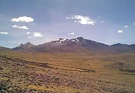
Some of the highest mountains in the district are Rasuwillka and Qarwarasu. Other mountains are listed below:[2]
- Anta P'ukru
- Anta Urqu
- Aqu P'ukru
- Aqu Urqu
- Chakra Pata
- Chunta
- Ichhu Qutu
- Jayuni
- Misk'i Pata
- Palla Palla
- Parqa Parqa
- Pawkaray
- Pichqaqucha
- Puka Muqu
- Puka Punchu
- Puka Salla
- Phiruru
- Qarwa Uqhu
- Qullpa Punta
- Q'illu Q'asa
- Q'illu Urqu
- Sallqan Tiwa
- Sapan Urqu
- Silla Q'asa
- Surapata
- Titi Q'asa
- Uqi
- Waman Pirqa
- Waych'ayuq
- Waylla Wit'u
- Waytayuq
- Yana Ranra
- Yana Yana
- Yunka
- Yuraq Pata
Ethnic groups
The people in the district are mainly indigenous citizens of Quechua descent. Quechua is the language which the majority of the population (73.03%) learnt to speak in childhood, 26.54% of the residents started speaking using the Spanish language (per the 2007 Peru Census).[3]
See also
References
- ↑ (in Spanish) Instituto Nacional de Estadística e Informática. Banco de Información Distrital Archived April 23, 2008, at the Wayback Machine. Retrieved April 11, 2008.
- ↑ escale.minedu.gob.pe - UGEL map of the Lucanas Province 2 (Ayacucho Region)
- ↑ inei.gob.pe Archived January 27, 2013, at the Wayback Machine INEI, Peru, Censos Nacionales 2007, Frequencias: Preguntas de Población: Idioma o lengua con el que aprendió hablar (in Spanish)
| |
|---|---|
| Cangallo | |
| Huamanga | |
| Huanca Sancos | |
| Huanta | |
| La Mar | |
| Lucanas | |
| Parinacochas | |
| Paucar del Sara Sara | |
| Sucre | |
| Víctor Fajardo | |
| Vilcas Huamán | |
This article is issued from Wikipedia. The text is licensed under Creative Commons - Attribution - Sharealike. Additional terms may apply for the media files.