Fleurance | |
|---|---|
 Saint-Laurent | |
.svg.png.webp) Coat of arms | |
Location of Fleurance | |
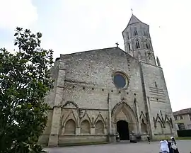
 Fleurance  Fleurance | |
| Coordinates: 43°51′01″N 0°39′52″E / 43.8503°N 0.6644°E | |
| Country | France |
| Region | Occitania |
| Department | Gers |
| Arrondissement | Condom |
| Canton | Fleurance-Lomagne |
| Intercommunality | Lomagne Gersoise |
| Government | |
| • Mayor (2020–2026) | Ronny Guardia-Mazzoleni[1] |
| Area 1 | 43.32 km2 (16.73 sq mi) |
| Population | 6,012 |
| • Density | 140/km2 (360/sq mi) |
| Time zone | UTC+01:00 (CET) |
| • Summer (DST) | UTC+02:00 (CEST) |
| INSEE/Postal code | 32132 /32500 |
| Elevation | 83–181 m (272–594 ft) (avg. 98 m or 322 ft) |
| 1 French Land Register data, which excludes lakes, ponds, glaciers > 1 km2 (0.386 sq mi or 247 acres) and river estuaries. | |
Fleurance (French pronunciation: [flœʁɑ̃s]; Occitan: Florença) is a commune in the Gers department in southwestern France.
Geography

Fleurance and its surrounding communes
Population
|
| |||||||||||||||||||||||||||||||||||||||||||||||||||||||||||||||||||||||||||||||||||||||||||||||||||||||||||||||
| Source: EHESS[3] and INSEE (1968-2017)[4] | ||||||||||||||||||||||||||||||||||||||||||||||||||||||||||||||||||||||||||||||||||||||||||||||||||||||||||||||||
See also
References
- ↑ "Répertoire national des élus: les maires" (in French). data.gouv.fr, Plateforme ouverte des données publiques françaises. 13 September 2022.
- ↑ "Populations légales 2021". The National Institute of Statistics and Economic Studies. 28 December 2023.
- ↑ Des villages de Cassini aux communes d'aujourd'hui: Commune data sheet Fleurance, EHESS (in French).
- ↑ Population en historique depuis 1968, INSEE
Wikimedia Commons has media related to Fleurance.
This article is issued from Wikipedia. The text is licensed under Creative Commons - Attribution - Sharealike. Additional terms may apply for the media files.