Grazierville, Pennsylvania | |
|---|---|
 Grazierville | |
| Coordinates: 40°39′13″N 78°15′53″W / 40.65361°N 78.26472°W | |
| Country | United States |
| State | Pennsylvania |
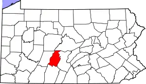
| County | Blair |
| Township | Snyder |
| Area | |
| • Total | 1.07 sq mi (2.78 km2) |
| • Land | 1.07 sq mi (2.78 km2) |
| • Water | 0.00 sq mi (0.00 km2) |
| Elevation | 1,030 ft (310 m) |
| Population | |
| • Total | 670 |
| • Density | 624.42/sq mi (241.13/km2) |
| Time zone | UTC-5 (Eastern (EST)) |
| • Summer (DST) | UTC-4 (EDT) |
| ZIP code | 16686[3] |
| Area code | 814 |
| FIPS code | 42-30704 |
| GNIS feature ID | 2630012 |
Grazierville is a census-designated place[4] in Snyder Township, Blair County, Pennsylvania, United States. It is located near I-99 and is approximately one mile to the south of the borough of Tyrone. As of the 2010 census, the population was 665 residents.[5]
Demographics
| Census | Pop. | Note | %± |
|---|---|---|---|
| 2020 | 670 | — | |
| U.S. Decennial Census[6] | |||
References
- ↑ "ArcGIS REST Services Directory". United States Census Bureau. Retrieved October 12, 2022.
- ↑ "Census Population API". United States Census Bureau. Retrieved October 12, 2022.
- ↑ "Grazierville PA ZIP Code". zipdatamaps.com. 2023. Retrieved June 27, 2023.
- ↑ "2010 U.S. Census website". United States Census Bureau. Retrieved February 10, 2013.
- ↑ "U.S. Census website". United States Census Bureau. Retrieved May 14, 2011.
- ↑ "Census of Population and Housing". Census.gov. Retrieved June 4, 2016.
External links
This article is issued from Wikipedia. The text is licensed under Creative Commons - Attribution - Sharealike. Additional terms may apply for the media files.