Ore Hill, Pennsylvania | |
|---|---|
 Ore Hill  Ore Hill | |
| Coordinates: 40°17′35″N 78°24′7″W / 40.29306°N 78.40194°W | |
| Country | United States |
| State | Pennsylvania |
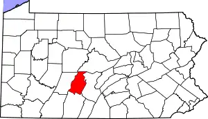
| County | Blair |
| Township | Taylor |
| Area | |
| • Total | 0.12 sq mi (0.31 km2) |
| • Land | 0.12 sq mi (0.31 km2) |
| • Water | 0.00 sq mi (0.00 km2) |
| Elevation | 1,455 ft (443 m) |
| Population | |
| • Total | 106 |
| • Density | 883.33/sq mi (340.78/km2) |
| Time zone | UTC-5 (Eastern (EST)) |
| • Summer (DST) | UTC-4 (EDT) |
| ZIP Code | 16673 (Roaring Spring) |
| Area code(s) | 814/582 |
| FIPS code | 42-57016 |
| GNIS feature ID | 2805537[3] |
Ore Hill is an unincorporated community and census-designated place (CDP) in Blair County, Pennsylvania, United States. It was first listed as a CDP prior to the 2020 census.[3]
The CDP is on the southern edge of Blair County, in the southern part of Taylor Township along the Bedford County line. It is 3 miles (5 km) south of the borough of Roaring Spring.
Demographics
| Census | Pop. | Note | %± |
|---|---|---|---|
| 2020 | 106 | — | |
| U.S. Decennial Census[4] | |||
References
- ↑ "ArcGIS REST Services Directory". United States Census Bureau. Retrieved October 12, 2022.
- ↑ "Census Population API". United States Census Bureau. Retrieved October 12, 2022.
- 1 2 "Ore Hill Census Designated Place". Geographic Names Information System. United States Geological Survey, United States Department of the Interior.
- ↑ "Census of Population and Housing". Census.gov. Retrieved June 4, 2016.
This article is issued from Wikipedia. The text is licensed under Creative Commons - Attribution - Sharealike. Additional terms may apply for the media files.