Hargis, Kentucky | |
|---|---|
 Hargis  Hargis | |
| Coordinates: 37°50′29″N 82°58′38″W / 37.84139°N 82.97722°W | |
| Country | United States |
| State | Kentucky |
| County | Johnson |
| Elevation | 915 ft (279 m) |
| Time zone | UTC-5 (Eastern (EST)) |
| • Summer (DST) | UTC-4 (EDT) |
| GNIS feature ID | 508188 |
Hargis is an unincorporated community in Johnson County, Kentucky, United States. It is located at an elevation of 915 feet (279 m).[1] It is located in the ZIP Code Tabulation Area (ZCTA) for ZIP code 41238.
References
- ↑ U.S. Geological Survey Geographic Names Information System: Hargis, Kentucky Retrieved on 2010-1-6
Municipalities and communities of Johnson County, Kentucky, United States | ||
|---|---|---|
| City | 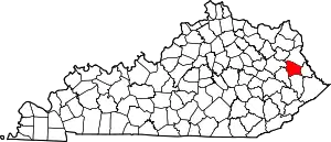 Location of Johnson County, Kentucky | |
| CDPs | ||
| Other unincorporated communities |
| |
This article is issued from Wikipedia. The text is licensed under Creative Commons - Attribution - Sharealike. Additional terms may apply for the media files.