West Van Lear, Kentucky | |
|---|---|
 West Van Lear  West Van Lear | |
| Coordinates: 37°47′10″N 82°46′50″W / 37.78611°N 82.78056°W | |
| Country | United States |
| State | Kentucky |
| County | Johnson |
| Area | |
| • Total | 1.12 sq mi (2.90 km2) |
| • Land | 1.09 sq mi (2.82 km2) |
| • Water | 0.03 sq mi (0.09 km2) |
| Population (2020) | |
| • Total | 768 |
| • Density | 705.88/sq mi (272.65/km2) |
| Time zone | UTC-5 (Eastern (EST)) |
| • Summer (DST) | UTC-4 (EDT) |
| FIPS code | 21-82056 |
West Van Lear is an unincorporated community in Johnson County, Kentucky, United States. Even though it is unincorporated, it has a post office and its own ZIP code (41268).[2] It has a small grocery store, a volunteer fire department, and a community center.
West Van Lear's post office was established on April 29, 1912, with James H. Price as postmaster.[3]
Demographics
| Census | Pop. | Note | %± |
|---|---|---|---|
| 2020 | 768 | — | |
| U.S. Decennial Census[4] | |||
References
- ↑ "2020 U.S. Gazetteer Files". United States Census Bureau. Retrieved March 18, 2022.
- ↑ "Johnson County, Kentucky ZIP Codes". Kentucky.hometownlocator.com. Retrieved March 19, 2012.
- ↑ Rennick, Robert M. (1988). "Place Names". Kentucky Place Names. Lexington, Kentucky: The University Press of Kentucky. ISBN 0-8131-0179-4.
- ↑ "Census of Population and Housing". Census.gov. Retrieved June 4, 2016.
Municipalities and communities of Johnson County, Kentucky, United States | ||
|---|---|---|
| City | 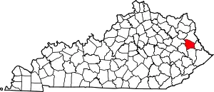 Location of Johnson County, Kentucky | |
| CDPs | ||
| Other unincorporated communities |
| |
This article is issued from Wikipedia. The text is licensed under Creative Commons - Attribution - Sharealike. Additional terms may apply for the media files.