Kümmersbruck | |
|---|---|
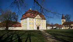 Theuern Castle | |
 Coat of arms | |
Location of Kümmersbruck within Amberg-Sulzbach district  | |
 Kümmersbruck 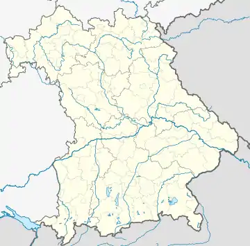 Kümmersbruck | |
| Coordinates: 49°25′N 11°53′E / 49.417°N 11.883°E | |
| Country | Germany |
| State | Bavaria |
| Admin. region | Oberpfalz |
| District | Amberg-Sulzbach |
| Government | |
| • Mayor (2020–26) | Roland Strehl[1] (CSU) |
| Area | |
| • Total | 46.38 km2 (17.91 sq mi) |
| Highest elevation | 490 m (1,610 ft) |
| Lowest elevation | 370 m (1,210 ft) |
| Population (2022-12-31)[2] | |
| • Total | 9,894 |
| • Density | 210/km2 (550/sq mi) |
| Time zone | UTC+01:00 (CET) |
| • Summer (DST) | UTC+02:00 (CEST) |
| Postal codes | 92245 |
| Dialling codes | 09621, 09624 (Theuern) |
| Vehicle registration | AS |
| Website | www.kuemmersbruck.de |
Kümmersbruck is a municipality in the Amberg-Sulzbach district, in the state of Bavaria, Germany. It is situated 3 km southeast of Amberg. A division of the German Military is stationed here. Kümmersbruck is split up in 7 districts: Kümmersbruck, Haselmühl, Gärmersdorf, Moos, Haidweiher, Penkhof, Lengenfeld and Engelsdorf. The river Vils crosses the municipality.
Town twinnings
Kümmersbruck is twinned with:
References
- ↑ Liste der ersten Bürgermeister/Oberbürgermeister in kreisangehörigen Gemeinden, Bayerisches Landesamt für Statistik, 15 July 2021.
- ↑ Genesis Online-Datenbank des Bayerischen Landesamtes für Statistik Tabelle 12411-003r Fortschreibung des Bevölkerungsstandes: Gemeinden, Stichtag (Einwohnerzahlen auf Grundlage des Zensus 2011)
Towns and municipalities in Amberg-Sulzbach | ||
|---|---|---|
| Coat of Arms of Amberg-Sulzbach district | |
This article is issued from Wikipedia. The text is licensed under Creative Commons - Attribution - Sharealike. Additional terms may apply for the media files.