Les Nans | |
|---|---|
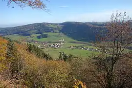 A general view of Les Nans | |
Location of Les Nans | |
 Les Nans  Les Nans | |
| Coordinates: 46°47′30″N 5°58′31″E / 46.7917°N 5.9753°E | |
| Country | France |
| Region | Bourgogne-Franche-Comté |
| Department | Jura |
| Arrondissement | Lons-le-Saunier |
| Canton | Champagnole |
| Government | |
| • Mayor (2020–2026) | Gilles Cicolini[1] |
| Area 1 | 8.05 km2 (3.11 sq mi) |
| Population | 97 |
| • Density | 12/km2 (31/sq mi) |
| Time zone | UTC+01:00 (CET) |
| • Summer (DST) | UTC+02:00 (CEST) |
| INSEE/Postal code | 39381 /39300 |
| Elevation | 635–904 m (2,083–2,966 ft) |
| 1 French Land Register data, which excludes lakes, ponds, glaciers > 1 km2 (0.386 sq mi or 247 acres) and river estuaries. | |
Les Nans (French pronunciation: [le nɑ̃]) is a commune in the Jura department in Bourgogne-Franche-Comté in eastern France.[3]
Population
| Year | Pop. | ±% p.a. |
|---|---|---|
| 1968 | 104 | — |
| 1975 | 89 | −2.20% |
| 1982 | 116 | +3.86% |
| 1990 | 100 | −1.84% |
| 1999 | 83 | −2.05% |
| 2009 | 89 | +0.70% |
| 2014 | 87 | −0.45% |
| 2020 | 98 | +2.00% |
| Source: INSEE[4] | ||
See also
References
- ↑ "Répertoire national des élus: les maires". data.gouv.fr, Plateforme ouverte des données publiques françaises (in French). 2 December 2020.
- ↑ "Populations légales 2021". The National Institute of Statistics and Economic Studies. 28 December 2023.
- ↑ INSEE commune file
- ↑ Population en historique depuis 1968, INSEE
Wikimedia Commons has media related to Les Nans.
This article is issued from Wikipedia. The text is licensed under Creative Commons - Attribution - Sharealike. Additional terms may apply for the media files.