
Administrative Divisions of Central Kalimantan Province, Indonesia
Here is the list of regencies and city in Central Kalimantan province. As of January 2021, there are 13 regencies and 1 city[1]
| No. | Code[2] | Regency/City[2] | Capital | Area (km2 & sq mi)[2] | Population (2020)[1] | Districts[2] | Subdistricts/Villages[2] | HDI 2022[3] | Logo | Location map |
|---|---|---|---|---|---|---|---|---|---|---|
| 1 | 62.13 | East Barito Regency | Tamiang Layang | 3,834 km2 (1,480 sq mi) | 113,229 | 10 | 3/101 | 0.721 (High) |  |
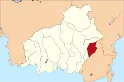 |
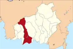
| 2 | 62.02 | East Kotawaringin Regency | Sampit | 16,796 km2 (6,485 sq mi) | 428,895 | 17 | 17/168 | 0.717 (High) |  |
 |
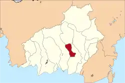
| 3 | 62.10 | Gunung Mas Regency | Kuala Kurun | 10,805 km2 (4,172 sq mi) | 135,373 | 12 | 12/115 | 0.714 (High) | 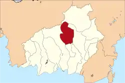 | |
| 4 | 62.03 | Kapuas Regency | Kuala Kapuas | 14,999 km2 (5,791 sq mi) | 410,446 | 17 | 17/214 | 0.700 (High) |  |
 |
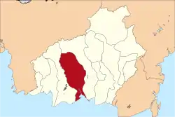
| 5 | 62.06 | Katingan Regency | Kasongan | 17,500 km2 (6,800 sq mi) | 162,222 | 13 | 7/154 | 0.697 (Medium) | 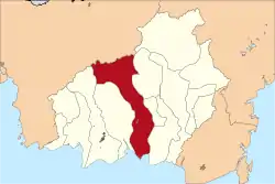 | |
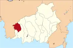
| 6 | 62.09 | Lamandau Regency | Nanga Bulik | 6,414 km2 (2,476 sq mi) | 97,611 | 8 | 3/85 | 0.711 (High) |  |
 |
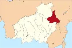
| 7 | 62.12 | Murung Raya Regency | Puruk Cahu | 23,700 km2 (9,200 sq mi) | 111,527 | 10 | 9/116 | 0.686 (Medium) |  |
 |
| 8 | 62.05 | North Barito Regency | Muara Teweh | 8,300 km2 (3,200 sq mi) | 154,812 | 9 | 10/93 | 0.712 (High) |  |
 |
| 9 | 62.11 | Pulang Pisau Regency | Pulang Pisau | 8,997 km2 (3,474 sq mi) | 134,499 | 8 | 4/95 | 0.690 (Medium) |  |
 |
| 10 | 62.71 | Palangka Raya City | - | 2,399.50 km2 (926.45 sq mi) | 293,457 | 5 | 30/- | 0.812 (Very High) |  |
 |
| 11 | 62.07 | Seruyan Regency | Kuala Pembuang | 16,404 km2 (6,334 sq mi) | 162,906 | 10 | 3/97 | 0.682 (Medium) |  |
 |
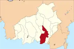
| 12 | 62.04 | South Barito Regency | Buntok Kota | 8,830 km2 (3,410 sq mi) | 131,140 | 6 | 7/86 | 0.710 (High) | 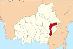 | |
| 13 | 62.08 | Sukamara Regency | Sukamara | 3,827 km2 (1,478 sq mi) | 63,464 | 5 | 3/29 | 0.689 (Medium) |  |
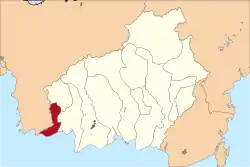 |
| 14 | 62.01 | West Kotawaringin Regency | Pangkalan Bun | 10,759 km2 (4,154 sq mi) | 270,388 | 6 | 13/81 | 0.734 (High) | 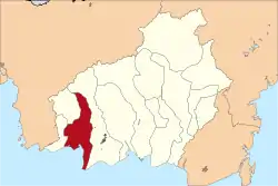 | |
Reference
- 1 2 "Population Census of Central Kalimantan Province in 2020" (in Indonesian). Statistic Agency of Central Kalimantan. January 2021. Retrieved 2 February 2021.
- 1 2 3 4 5 "Code and Data of Administrative Divisions (Permendagri No.137-2017) - Ministry of Home Affairs - Republic of Indonesia". www.kemendagri.go.id. Archived from the original on 2017-04-29. Retrieved 2018-07-11.
- ↑ "Official Statistics of Central Kalimantan" (PDF) (in Indonesian). BPS Provinsi Kalimantan Tengah. December 2022. p. 45. Retrieved 25 May 2023.
List of regencies and cities of Indonesia by provinces | ||
|---|---|---|
| Sumatra |  | |
| Java |
| |
| Kalimantan |
| |
| Nusa Tenggara |
| |
| Sulawesi |
| |
| Maluku |
| |
| Papua |
| |
Source: "www.kemendagri.go.id" (PDF) (in Indonesian). | ||
This article is issued from Wikipedia. The text is licensed under Creative Commons - Attribution - Sharealike. Additional terms may apply for the media files.