Map of Saint Lucia, with topographic relief.
Map of Saint Lucia (flat).

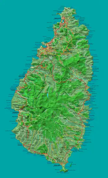
This is a list of rivers in the island country of Saint Lucia. Rivers are listed in clockwise order, starting at the north end of the island.

Rivers

There are 180 streams in Saint Lucia. Most of the rivers empty into the Atlantic Ocean or Caribbean Sea at the coast of Saint Lucia. (The location of the river mouths indicated in this list. Only Roseau and Migny rivers are not on the coast.) The longest river is the Roseau River with a drainage area of 48 km2 (19 sq mi). There are 28 drainage basins for rivers of Saint Lucia.[1][2][3][4][5]

Rivers in Saint Lucia
Order Name Location of mouth
1Trou Sallé River 14°04′46″N 60°55′12″W / 14.07933°N 60.91998°W / 14.07933; -60.91998 (Trou Sallé River)
2Esperance River[6] 14°03′37″N 60°54′45″W / 14.06035°N 60.912549°W / 14.06035; -60.912549 (Esperance River)
3Dauphin River 14°02′24″N 60°53′46″W / 14.039893°N 60.896231°W / 14.039893; -60.896231 (Dauphin River)
4Trou Grauval River 14°03′29″N 60°53′30″W / 14.058146°N 60.891576°W / 14.058146; -60.891576 (Trou Grauval River)
5Marquis River[6] 14°01′52″N 60°53′44″W / 14.031239°N 60.895603°W / 14.031239; -60.895603 (Marquis River)
6Louvet River[6] 13°57′53″N 60°52′48″W / 13.964849°N 60.880013°W / 13.964849; -60.880013 (Louvet River)
7Fond d'Or River 13°55′23″N 60°53′25″W / 13.923034°N 60.890274°W / 13.923034; -60.890274 (Fond D'Or River)
8Dennery River[6] 13°54′30″N 60°53′26″W / 13.908223°N 60.890515°W / 13.908223; -60.890515 (Dennery River)
9Praslin River
(Rivière des Trois Islets)
13°52′44″N 60°53′45″W / 13.878953°N 60.895872°W / 13.878953; -60.895872 (Praslin River)
10Mamiku River 13°52′18″N 60°53′49″W / 13.871644°N 60.896985°W / 13.871644; -60.896985 (Mamiku River)
11Patience River 13°51′28″N 60°53′19″W / 13.857662°N 60.888741°W / 13.857662; -60.888741 (Patience River)
12Fond River 13°49′56″N 60°53′36″W / 13.832279°N 60.893467°W / 13.832279; -60.893467 (Fond River)
13Volet River[6] 13°49′38″N 60°54′01″W / 13.82713°N 60.900247°W / 13.82713; -60.900247 (Volet River)
14Troumassée River[6] 13°48′46″N 60°53′50″W / 13.812815°N 60.897106°W / 13.812815; -60.897106 (Troumassée River)
15Ger River 13°47′49″N 60°54′02″W / 13.79696°N 60.90066°W / 13.79696; -60.90066 (Ger River)
16Canelles River[6] 13°46′50″N 60°54′14″W / 13.780547°N 60.903878°W / 13.780547; -60.903878 (Canelles River)
17Rouarne River 13°45′59″N 60°55′06″W / 13.76643°N 60.918283°W / 13.76643; -60.918283 (Rouarne River)
18Vieux Fort River[6] 13°43′50″N 60°58′07″W / 13.7306°N 60.968675°W / 13.7306; -60.968675 (Vieux Fort River)
18aLittle Vieux Fort River
19Black Bay River[6] 13°44′11″N 60°58′51″W / 13.736416°N 60.980721°W / 13.736416; -60.980721 (Black Bay River)
20Piaye River[6] 13°45′10″N 61°01′09″W / 13.752907°N 61.019287°W / 13.752907; -61.019287 (Piaye River)
21Balembouche River[6] 13°45′15″N 61°01′32″W / 13.754224°N 61.025493°W / 13.754224; -61.025493 (Balembouche River)
22Dorée River[6] 13°45′33″N 61°02′15″W / 13.75923°N 61.03755°W / 13.75923; -61.03755 (Dorée River)
23Trou Barbet River 13°46′42″N 61°03′08″W / 13.778265°N 61.052134°W / 13.778265; -61.052134 (Trou Barbet River)
24Grande Rivière Choiseul 13°46′21″N 61°03′02″W / 13.772537°N 61.050564°W / 13.772537; -61.050564 (Grande Rivière Choiseul)
25L’Ivrogne River[6] 13°47′57″N 61°04′03″W / 13.799034°N 61.067587°W / 13.799034; -61.067587 (L’Ivrogne River)
26Soufrière River[6] 13°51′21″N 61°03′38″W / 13.855958°N 61.060629°W / 13.855958; -61.060629 (Soufrière River)
26aJeremy River
26bMigny River 13°51′13″N 61°02′11″W / 13.853701°N 61.036284°W / 13.853701; -61.036284 (Migny River)
27Mamin River 13°52′15″N 61°04′43″W / 13.870753°N 61.078527°W / 13.870753; -61.078527 (Mamin River)
28Mahaut River 13°53′32″N 61°04′25″W / 13.892304°N 61.073487°W / 13.892304; -61.073487 (Mahaut River)
29Canaries River[6] 13°54′18″N 61°04′08″W / 13.904901°N 61.068765°W / 13.904901; -61.068765 (Canaries River)
30La Verdure River 13°55′12″N 61°03′35″W / 13.920047°N 61.059635°W / 13.920047; -61.059635 (La Verdure River)
31Anse Cochon River 13°55′36″N 61°03′24″W / 13.926655°N 61.056695°W / 13.926655; -61.056695 (Anse Cochon River)
32Grande Rivière de l'Anse la Raye 13°56′21″N 61°02′39″W / 13.93915°N 61.04426°W / 13.93915; -61.04426 (Grande Rivière de l'Anse la Raye)
33Petite Riviere de l'Anse La Raye[6] 13°56′31″N 61°02′37″W / 13.942032°N 61.043529°W / 13.942032; -61.043529 (Petite Riviere de l'Anse La Raye)
34Roseau River[6] 13°57′36″N 61°01′57″W / 13.959965°N 61.032363°W / 13.959965; -61.032363 (Roseau River)
34aMillet River 13°55′29″N 60°59′22″W / 13.924778°N 60.989491°W / 13.924778; -60.989491 (Millet River)
35Cul de Sac River[6] 13°59′02″N 61°00′40″W / 13.983861°N 61.011162°W / 13.983861; -61.011162 (Cul de Sac River)
36Castries River[6] 14°00′34″N 60°59′38″W / 14.009554°N 60.994019°W / 14.009554; -60.994019 (Castries River)
37Choc River[6] 14°02′19″N 60°58′18″W / 14.038652°N 60.971711°W / 14.038652; -60.971711 (Choc River)
38Bois d'Orange River 14°03′56″N 60°57′59″W / 14.065454°N 60.966516°W / 14.065454; -60.966516 (Bois d'Orange River)

See also

Notes

Breen's list of major rivers in Saint Lucia in 1844 includes a Vide Bouteille River but there is no mention of this river in the current GeoNames database. There is a Vide Bouteille Point on the coast at 14°01′52″N 60°58′45″W / 14.03119°N 60.979239°W / 14.03119; -60.979239 (Vide Bouteille Point).[6][3]

References

  1. Higgins, Chris (2001). St. Lucia. Montreal: Ulysses Travel Guides. ISBN 2-89464-396-9.
  2. "Integrating the Management of Watersheds and Coastal Areas in St. Lucia". Water Resources Management Unit, Ministry of Agriculture, Forestry and Fisheries Government of St. Lucia. 2001. Retrieved August 3, 2021.
  3. 1 2 "GEONet Names Server". National Geospatial-Intelligence Agency. Retrieved June 25, 2021., GEOnet Names Server
  4. "Tourist Map". Caribbean On-line. Archived from the original on 2007-10-10. Retrieved August 4, 2021.
  5. Saint Lucia Country Environmental Profile (PDF). Caribbean Conservation Association. p. 44. Retrieved August 11, 2021.
  6. 1 2 3 4 5 6 7 8 9 10 11 12 13 14 15 16 17 18 19 20 21 Breen, Henry H. (1844). St. Lucia: Historical, Statistical, and Descriptive. London: Longman, Brown, Green, and Longmans. p. 10.
This article is issued from Wikipedia. The text is licensed under Creative Commons - Attribution - Sharealike. Additional terms may apply for the media files.