Monterville, West Virginia | |
|---|---|
 | |
 Monterville, West Virginia  Monterville, West Virginia | |
| Coordinates: 38°33′32″N 80°06′18″W / 38.55889°N 80.10500°W | |
| Country | United States |
| State | West Virginia |
| County | Randolph |
| Elevation | 3,271 ft (997 m) |
| Time zone | UTC-5 (Eastern (EST)) |
| • Summer (DST) | UTC-4 (EDT) |
| ZIP code | 26282[2] |
| Area code(s) | 304 & 681 |
| GNIS feature ID | 1555153<[1] |
Monterville is an unincorporated community in Randolph County, West Virginia, United States. Monterville is 12.5 miles (20.1 km) southwest of Huttonsville. Monterville had a post office, which closed on June 20, 2009.[3]
John Ernest Monterville Bing, an early postmaster, gave the community his name.[4]
References
- 1 2 U.S. Geological Survey Geographic Names Information System: Monterville, West Virginia
- ↑ United States Postal Service (2012). "USPS - Look Up a ZIP Code". Retrieved February 15, 2012.
- ↑ "Postmaster Finder - Post Offices by ZIP Code". United States Postal Service. Retrieved January 1, 2012.
- ↑ Kenny, Hamill (1945). West Virginia Place Names: Their Origin and Meaning, Including the Nomenclature of the Streams and Mountains. Piedmont, WV: The Place Name Press. p. 426.
Municipalities and communities of Randolph County, West Virginia, United States | ||
|---|---|---|
| City | 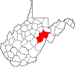 Map of West Virginia highlighting Randolph County | |
| Towns | ||
| CDPs | ||
| Other communities |
| |
| Ghost towns | ||
| Footnotes | ‡This populated place also has portions in an adjacent county or counties | |
This article is issued from Wikipedia. The text is licensed under Creative Commons - Attribution - Sharealike. Additional terms may apply for the media files.