Oberdorf im Burgenland | |
|---|---|
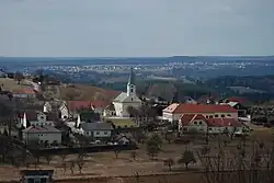 View of Oberdorf | |
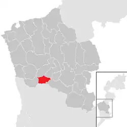 Location within Oberwart district | |
 Oberdorf im Burgenland Location within Austria | |
| Coordinates: 47°13′N 16°13′E / 47.217°N 16.217°E | |
| Country | Austria |
| State | Burgenland |
| District | Oberwart |
| Government | |
| • Mayor | Karl Halper |
| Area | |
| • Total | 9.24 km2 (3.57 sq mi) |
| Elevation | 364 m (1,194 ft) |
| Population (2018-01-01)[2] | |
| • Total | 996 |
| • Density | 110/km2 (280/sq mi) |
| Time zone | UTC+1 (CET) |
| • Summer (DST) | UTC+2 (CEST) |
| Postal code | 7501 |
Oberdorf im Burgenland (Hungarian: Őrállás) is a town in the district of Oberwart in the Austrian state of Burgenland.
Population
| Year | Pop. | ±% |
|---|---|---|
| 1869 | 756 | — |
| 1880 | 831 | +9.9% |
| 1890 | 974 | +17.2% |
| 1900 | 1,071 | +10.0% |
| 1910 | 942 | −12.0% |
| 1923 | 993 | +5.4% |
| 1934 | 1,115 | +12.3% |
| 1939 | 1,110 | −0.4% |
| 1951 | 1,133 | +2.1% |
| 1961 | 1,136 | +0.3% |
| 1971 | 1,119 | −1.5% |
| 1981 | 1,083 | −3.2% |
| 1991 | 1,080 | −0.3% |
| 2001 | 1,102 | +2.0% |
| 2011 | 1,039 | −5.7% |
References
- ↑ "Dauersiedlungsraum der Gemeinden Politischen Bezirke und Bundesländer - Gebietsstand 1.1.2018". Statistics Austria. Retrieved 10 March 2019.
- ↑ "Einwohnerzahl 1.1.2018 nach Gemeinden mit Status, Gebietsstand 1.1.2018". Statistics Austria. Retrieved 9 March 2019.
This article is issued from Wikipedia. The text is licensed under Creative Commons - Attribution - Sharealike. Additional terms may apply for the media files.