Piercys Mill, West Virginia | |
|---|---|
 Piercys Mill  Piercys Mill | |
| Coordinates: 37°50′37″N 80°34′25″W / 37.84361°N 80.57361°W | |
| Country | United States |
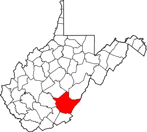
| State | West Virginia |
| County | Greenbrier |
| Elevation | 1,660 ft (510 m) |
| Time zone | UTC-5 (Eastern (EST)) |
| • Summer (DST) | UTC-4 (EDT) |
| Area code(s) | 304 & 681 |
| GNIS feature ID | 1555343[1] |
Piercys Mill is an unincorporated community in Greenbrier County, West Virginia, United States. Piercys Mill is 10.8 miles (17.4 km) north-northeast of Alderson.
Within the community is Piercy's Mill Cave, a privately-owned cavern that extends just under a mile.[2] A stream flows out of the cave's mouth and into Muddy Creek, a tributary of the Greenbrier River. A side passage inside of Piercy's Mill Cave leads to a series of rimstone dam rooms.[3]
References
- ↑ "US Board on Geographic Names". United States Geological Survey. October 25, 2007. Retrieved January 31, 2008.
- ↑ "Ludington Cave & Piercy's Mill Cave". GeoCities. Retrieved January 16, 2022.
- ↑ Rose, Tammy Marie (April 3, 2016). "Going Into These 6 West Virginia Caves Is Like Entering Another World". OnlyInYourState. Retrieved January 16, 2022.
This article is issued from Wikipedia. The text is licensed under Creative Commons - Attribution - Sharealike. Additional terms may apply for the media files.