Sárkeresztúr | |
|---|---|
Village | |
.jpg.webp) Church in Sárkeresztúr | |
 Flag  Coat of arms | |
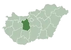
 Sárkeresztúr Location of Sárkeresztúr | |
| Coordinates: 47°00′09″N 18°32′52″E / 47.00242°N 18.54768°E | |
| Country | Hungary |
| Region | Central Transdanubia |
| County | Fejér |
| District | Sárbogárd |
| Area | |
| • Total | 46.75 km2 (18.05 sq mi) |
| Population (1 January 2023)[1] | |
| • Total | 2,519 |
| • Density | 54/km2 (140/sq mi) |
| Time zone | UTC+1 (CET) |
| • Summer (DST) | UTC+2 (CEST) |
| Postal code | 8125 |
| Area code | (+36) 25 |
| Website | www |
References
- ↑ Error: Unable to display the reference properly. See the documentation for details.
External links
- Street map (in Hungarian)
| Town (1) |
| |
|---|---|---|
| Large village (1) | ||
| Villages (10) | ||
| Cities with county rights |
|   |
|---|---|---|
| Towns | ||
| Large villages | ||
| Villages |
| |
| Other topics |
| |
This article is issued from Wikipedia. The text is licensed under Creative Commons - Attribution - Sharealike. Additional terms may apply for the media files.