Sapopemba | |
|---|---|
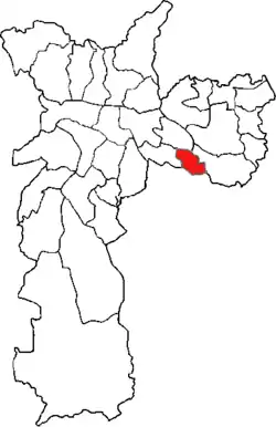 Location of the Subprefecture of Sapopemba in São Paulo | |
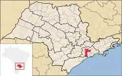 Location of municipality of São Paulo within the State of São Paulo | |
| Country | |
| Region | Southeast |
| State | |
| Municipality | |
| Administrative Zone | Southeast |
| Districts | Sapopemba |
| Government | |
| • Type | Subprefecture |
| • Subprefect | Benedito Gonçalves Pereira |
| Area | |
| • Total | 135 km2 (52 sq mi) |
| Population (2010)[1] | |
| • Total | 284,524 |
| Website | Subprefeitura Sapopemba (Portuguese) |
The Subprefecture of Sapopemba is one of 32 subprefectures of the city of São Paulo, Brazil. It comprises one district: Sapopemba. It is divided into 51 neighborhoods and its population density is 21,076 inhabitants/km2.[1] This subprefecture was founded in 2013 from a territory of the Subprefecture of Vila Prudente, which makes it the youngest subprefecture of the city of São Paulo.[2]
References
- 1 2 3 "Portal da Prefeitura da Cidade de São Paulo". www.prefeitura.sp.gov.br (in Portuguese). Retrieved 2017-05-02.
- ↑ "Batizada com nome de árvore, Sapopemba é a subprefeitura mais jovem da cidade". 32xSP.org.br (in Portuguese). 2016-10-17. Retrieved 2017-05-02.
This article is issued from Wikipedia. The text is licensed under Creative Commons - Attribution - Sharealike. Additional terms may apply for the media files.