Tar | |
|---|---|
 Coat of arms | |
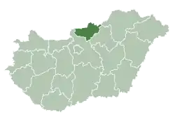
 Tar Location of Tar, Hungary | |
| Coordinates: 47°57′02″N 19°44′29″E / 47.95046°N 19.74131°E | |
| Country | |
| County | Nógrád |
| Area | |
| • Total | 27.34 km2 (10.56 sq mi) |
| Population (2004) | |
| • Total | 1,980 |
| • Density | 72.42/km2 (187.6/sq mi) |
| Time zone | UTC+1 (CET) |
| • Summer (DST) | UTC+2 (CEST) |
| Postal code | 3073 |
| Area code | 32 |
Tar is a village in Nógrád county, Hungary. There are some natural sources near here, for ex. Csevice source

Tar from a bird's eye view
External links
- Street map (in Hungarian)
This article is issued from Wikipedia. The text is licensed under Creative Commons - Attribution - Sharealike. Additional terms may apply for the media files.