Utica, Oklahoma | |
|---|---|
 Utica, Oklahoma  Utica, Oklahoma | |
| Coordinates: 33°54′18″N 96°13′17″W / 33.90500°N 96.22139°W | |
| Country | United States |
| State | Oklahoma |
| County | Bryan |
| Area | |
| • Total | 0.46 sq mi (1.19 km2) |
| • Land | 0.46 sq mi (1.19 km2) |
| • Water | 0.00 sq mi (0.00 km2) |
| Elevation | 600 ft (200 m) |
| Population (2020) | |
| • Total | 51 |
| • Density | 111.11/sq mi (42.92/km2) |
| Time zone | UTC-6 (Central (CST)) |
| • Summer (DST) | UTC-5 (CDT) |
| ZIP code | 74763 |
| Area code | 580 |
| GNIS feature ID | 2805358[2] |
Utica is an unincorporated community in Bryan County, Oklahoma, United States. Utica is 11 miles (18 km) southeast of Durant. Utica has a post office with ZIP code 74763.[3]
Demographics
| Census | Pop. | Note | %± |
|---|---|---|---|
| 2020 | 51 | — | |
| U.S. Decennial Census[4] | |||
References
- ↑ "ArcGIS REST Services Directory". United States Census Bureau. Retrieved September 20, 2022.
- 1 2 U.S. Geological Survey Geographic Names Information System: Utica, Oklahoma
- ↑ ZIP Code Lookup
- ↑ "Census of Population and Housing". Census.gov. Retrieved June 4, 2016.
Municipalities and communities of Bryan County, Oklahoma, United States | ||
|---|---|---|
| City | 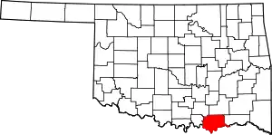 Bryan County map | |
| Towns | ||
| CDPs | ||
| Other communities | ||
| Ghost towns | ||
| Indian reservations | ||
| Footnotes | ‡This populated place also has portions in an adjacent county or counties | |
This article is issued from Wikipedia. The text is licensed under Creative Commons - Attribution - Sharealike. Additional terms may apply for the media files.